Topic
Text
Geospatial data and satellite intelligence are transforming infrastructure monitoring and climate risk assessment. By combining Earth Observation, AI and geospatial analytics, infrastructure operators can detect ground instability, monitor vegetation, assess climate hazards and prioritise maintenance. Latitudo 40 turns satellite data into actionable insights through EarthDataInsights and EarthDataPlace, supporting predictive asset management, climate resilience and sustainable infrastructure planning.
Article
Content
Why Infrastructure Monitoring Is Becoming a Climate Risk Challenge
Infrastructure systems are increasingly exposed to a combination of acute and chronic climate hazards that can affect asset performance, operational continuity and maintenance requirements. Floods, wildfires, heatwaves and storms can cause immediate physical damage, while longer-term changes in temperature, rainfall patterns, sea level and ground conditions can progressively degrade infrastructure and increase operating and maintenance costs.
For infrastructure owners and operators, this makes climate risk assessment an increasingly important component of asset management. Roads, railways, power grids, water systems and telecommunications networks can be affected differently depending on their location, physical characteristics and exposure to specific hazards. Understanding these spatial variations is therefore essential to identify vulnerable assets, prioritise adaptation measures and strengthen infrastructure resilience.
The challenge is particularly significant for geographically distributed infrastructure, where risks can emerge across extensive networks and interact with surrounding environmental conditions. A robust climate risk infrastructure strategy therefore requires more than post-event inspections: it requires reliable information on where risks are concentrated, how exposure evolves over time and which assets require attention.
This is driving infrastructure managers towards more systematic, data-driven approaches capable of supporting continuous risk assessment and informed adaptation decisions.
From Reactive Maintenance to Predictive Infrastructure Management
For infrastructure operators, effective asset maintenance increasingly depends on the ability to identify changing conditions before they develop into failures. Traditional inspection programmes remain essential, but relying primarily on scheduled surveys or post-event assessments can limit visibility across geographically distributed assets. A more proactive approach combines continuous monitoring with data-driven infrastructure risk management, allowing operators to identify anomalies, assess their significance and prioritise interventions according to actual risk.
This shift from reactive to preventive infrastructure maintenance is central to modern infrastructure asset management. By integrating environmental observations, historical data and asset information, infrastructure managers can detect emerging conditions, identify trends and direct inspection and maintenance resources towards the assets that require attention. Earth Observation can support this transition by providing consistent, spatially extensive information that complements field inspections and existing monitoring systems.
The result is a more dynamic approach to predictive infrastructure management: instead of treating maintenance as a fixed schedule, operators can use evidence on asset and environmental conditions to inform when and where action is needed. Over time, this approach can support more efficient infrastructure lifecycle management, helping organisations move from isolated inspections towards continuous risk-informed management of their physical assets.
How Satellite Data Supports Infrastructure Monitoring
Satellite monitoring extends infrastructure oversight beyond the physical inspection site, providing spatially consistent information across extensive and geographically distributed assets. Satellite imagery for infrastructure can support the observation of asset surroundings, environmental conditions and changes over time, complementing field surveys and existing monitoring systems. This makes Earth Observation for infrastructure particularly relevant where conventional inspections are difficult, costly or limited to specific points.
Different satellite sensors provide complementary information. Optical and multispectral imagery can characterise land cover, vegetation and surface conditions, while Synthetic Aperture Radar (SAR) enables remote sensing for infrastructure independently of daylight and cloud cover. Sentinel-1, for example, provides all-weather, day-and-night radar imagery and supports monitoring of land-surface motion.
For satellite-based infrastructure monitoring, the value therefore lies not only in image acquisition but in the systematic processing of Earth Observation data into information that can be integrated into infrastructure management workflows.
By combining broad spatial coverage with recurring observations, remote infrastructure monitoring can provide a scalable evidence base for identifying changes, assessing exposure and supporting more targeted inspections and interventions.
Key Applications of Geospatial Intelligence in Infrastructure Management
Geospatial intelligence for infrastructure combines Earth Observation data, spatial analysis and AI to provide a more detailed understanding of asset conditions and their surrounding environment. For infrastructure operators, its value lies in connecting geographically referenced observations with operational processes, helping identify areas requiring attention and supporting more targeted infrastructure risk assessment. Applications range from monitoring ground stability to assessing vegetation, climate hazards and environmental changes across extensive networks.
Ground Stability and Infrastructure Deformation
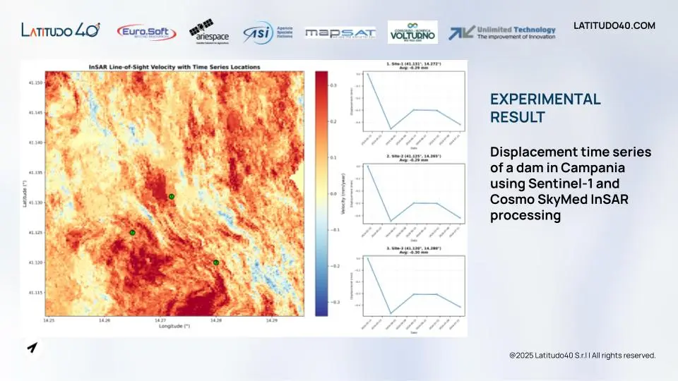
InSAR infrastructure monitoring enables the detection and measurement of ground and infrastructure movements over time. Radar-based interferometric analysis can identify subsidence, deformation and other displacement patterns that may indicate geological instability or affect roads, railways, bridges, tunnels and utility networks. ESA programmes such as IRIDE identify land-motion monitoring as a key application for detecting movements associated with subsidence, landslides and other hazards.
Vegetation and Environmental Monitoring
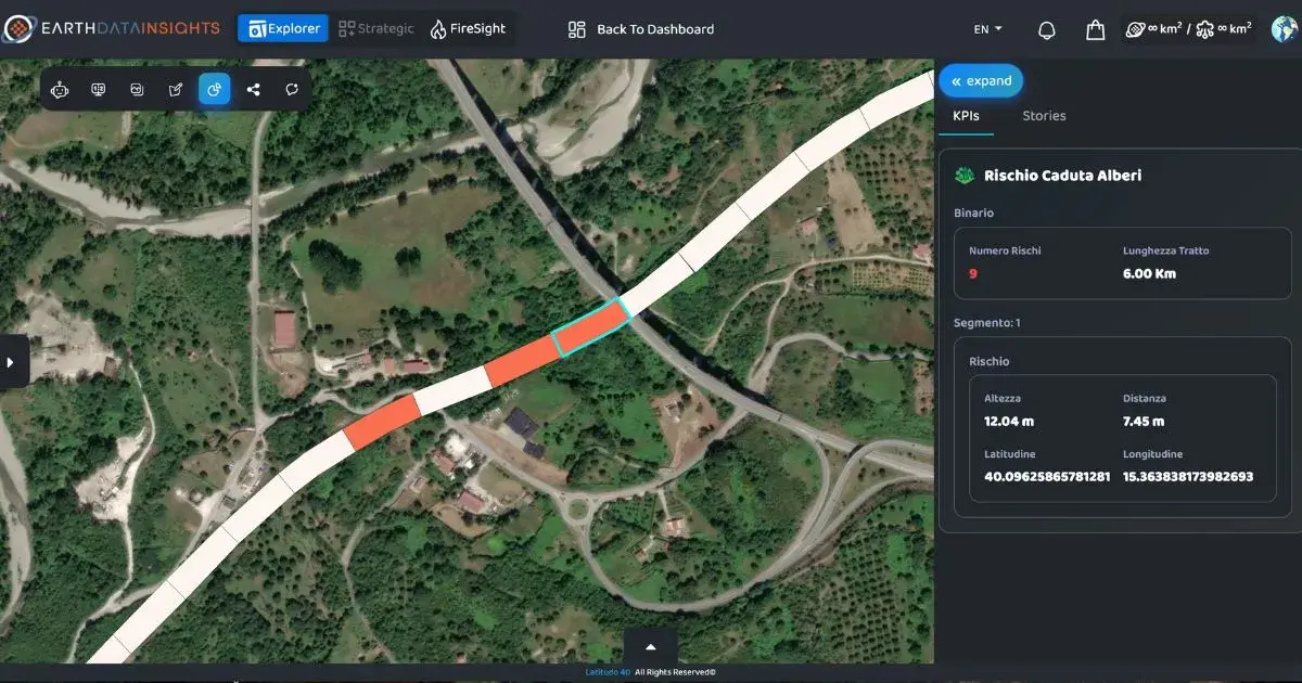
Vegetation monitoring for infrastructure is particularly relevant to linear assets such as electricity grids and railways. Satellite imagery and AI can identify vegetation encroachment, monitor changes within infrastructure corridors and support the prioritisation of maintenance activities. ESA projects demonstrate how multi-source EO data can be combined with AI to detect vegetation interference and assess associated risks at network scale.
Climate Hazard and Risk Assessment
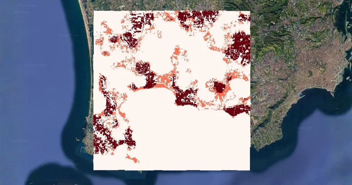
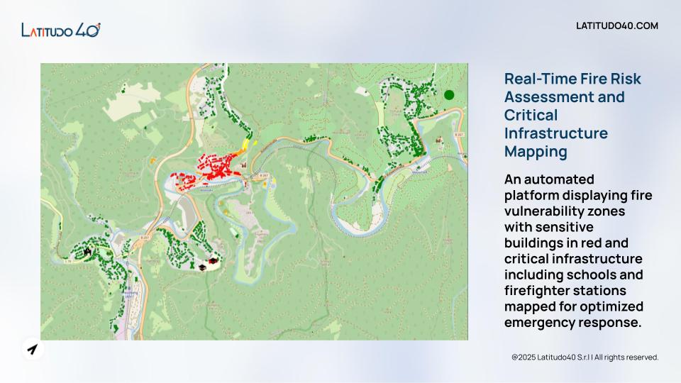
Climate risk assessment for infrastructure can combine satellite observations with environmental and geospatial datasets to identify exposure to hazards such as flooding, wildfires, extreme weather and changing land conditions. This supports infrastructure resilience by providing spatial evidence for risk identification, emergency response and adaptation planning. Earth Observation systems can also provide multi-temporal information to assess how exposure and environmental conditions evolve over time.
Infrastructure Condition and Change Detection
Satellite monitoring for infrastructure can support systematic change detection across large and distributed asset networks. Comparing observations acquired at different times makes it possible to identify changes in land use, construction activity, environmental conditions or other factors that may affect infrastructure operations. ESA initiatives have demonstrated the use of optical and radar data, combined with AI, to identify critical areas and prioritise more detailed inspections.
Sustainability and Infrastructure Asset Management
Finally, geospatial intelligence can extend beyond risk detection to support sustainable infrastructure management. Environmental indicators derived from satellite data can inform asset planning, resource management and sustainability assessments, while spatial analysis can support decisions concerning renewable energy potential and environmental performance. For infrastructure operators, integrating these insights into existing asset management processes creates a broader evidence base for managing physical assets throughout their lifecycle. Latitudo 40 applies this approach through geospatial analyses, environmental KPIs and integration with GIS, ERP and asset management systems.
How Latitudo 40 Supports Infrastructure and Utility Operators
Latitudo 40 combines Earth Observation data, proprietary AI algorithms and geospatial intelligence to support infrastructure and utility operators across monitoring, risk assessment and asset management. Its technology ecosystem is built around two complementary platforms. EarthDataInsights is a SaaS environment for monitoring environmental change and climate risks through interactive dashboards, continuous monitoring and scenario simulation. It transforms satellite-derived information into operational indicators and enables users to compare current conditions with potential future scenarios.
EarthDataPlace, by contrast, is a marketplace for ready-to-use geospatial analyses and satellite-derived data, designed for direct integration into existing systems and workflows. Its outputs can be used independently or integrated with GIS, ERP, asset management and maintenance-planning environments. The catalogue includes high-resolution environmental layers, with recurring monitoring and historical information available for analysis.
Together, these platforms allow infrastructure organisations to move from raw Earth Observation data to actionable intelligence, supporting both portfolio-level screening and targeted asset analysis.
Advanced Geological Monitoring with InSAR
Latitudo 40 applies InSAR technology for infrastructure monitoring to analyse ground and asset stability. An experimental case study on a dam in Campania demonstrated displacement time-series analysis using Sentinel-1 and COSMO-SkyMed InSAR processing. This capability can support the identification of subsidence, ground movements and other signals associated with geological instability, providing an additional layer of evidence for infrastructure risk management.
AI-Powered Predictive Risk Intelligence
Latitudo 40 combines geospatial data and AI to identify environmental conditions that may require intervention and support predictive infrastructure management. In the MIDS project, satellite data, AI and GIS were combined to monitor critical water infrastructure, including dams and weirs, with the objective of enabling continuous observation and models for predicting potential infrastructure failures.
Automated Vegetation Interference Monitoring
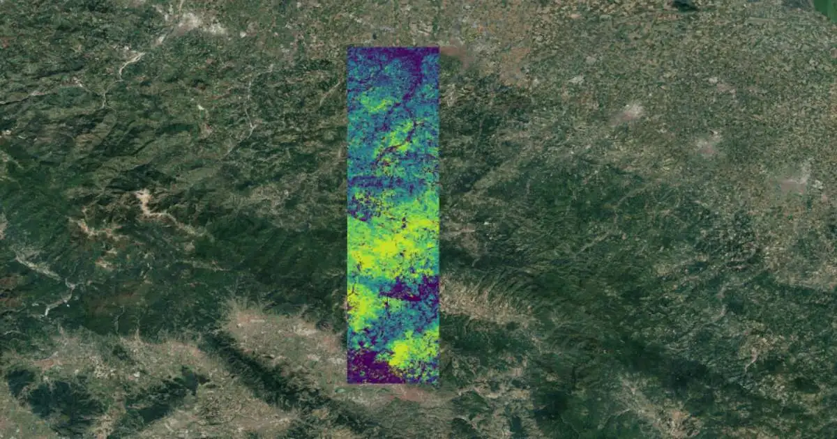
Vegetation encroachment can represent a significant operational risk for linear infrastructure. Latitudo 40's geospatial analytics can support the detection and assessment of vegetation conditions around infrastructure corridors. In the Railsat project, AI-powered analytics were used to identify railway vulnerabilities, including ground instability and vegetation encroachment. A dedicated application in Cilento used the Tree Heights Classification layer to identify areas where vegetation height could create safety hazards along a railway.
Interoperable Geospatial Data and APIs
Latitudo 40 is designed to integrate geospatial intelligence into existing operational environments rather than replace them. Its infrastructure combines heterogeneous optical, radar and multispectral satellite sources through APIs, while environmental indicators can be exported and integrated into GIS, ERP and asset-management systems. This interoperability makes satellite-based monitoring applicable to established inspection, maintenance and infrastructure-management workflows.
Climate Intelligence for Asset Management and Sustainability
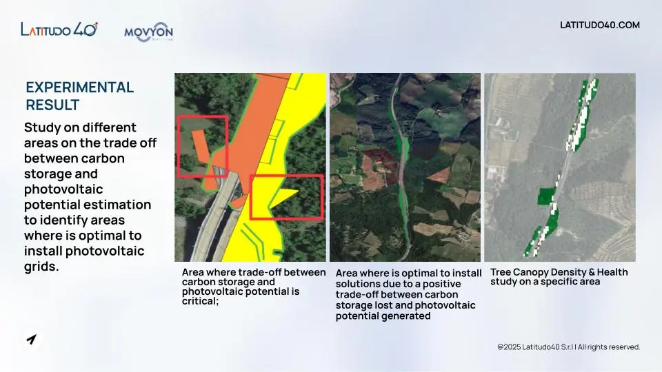
The same geospatial intelligence can support infrastructure sustainability by assessing trade-offs between different land-use and environmental objectives. In the Movyon case study, Latitudo 40 analysed more than 300 areas along the road network to quantify the carbon storage provided by existing vegetation and assess their photovoltaic potential.
The analysis supported the identification of areas where photovoltaic installations could be developed while considering the carbon storage potentially lost through vegetation removal. By combining the Carbon Storage and Photovoltaic Potential Estimation layers, Latitudo 40 provided a spatial assessment of this trade-off, helping identify locations where the potential energy benefit was most favourable relative to the environmental cost.
This approach extends infrastructure asset management beyond physical condition and climate risk, enabling operators to evaluate sustainability interventions through quantitative geospatial intelligence.
From Satellite Monitoring to Dynamic Infrastructure Management
Infrastructure management is evolving from periodic inspection to continuous, data-driven decision-making. By combining satellite monitoring, Earth Observation and geospatial intelligence, infrastructure and utility operators can move beyond simply observing assets to understanding how their condition, environmental exposure and climate-related risks evolve over time.
The real value lies in connecting this intelligence to action: identifying emerging risks, prioritising inspections and maintenance, assessing intervention scenarios and supporting investment decisions across the infrastructure lifecycle. This enables a shift towards predictive infrastructure management, where decisions are informed by continuously updated evidence rather than isolated inspections or historical assumptions.
For organisations managing extensive and distributed asset networks, this approach can strengthen infrastructure asset management while supporting long-term infrastructure resilience. By transforming satellite data into actionable intelligence, Latitudo 40 helps operators build a more dynamic understanding of their assets and the environments around them—providing the intelligence needed to anticipate risks, optimise interventions and plan more climate-resilient infrastructure.
Do you want to learn more?