.svg)


.svg)

Topic
Text
Geospatial data and earth observation are reshaping carbon storage and carbon sequestration measurement for ESG and carbon credit markets. From IPCC-based fire risk analytics to automated reporting, solutions like the EarthDataInsights platform by Latitudo40 convert satellite data into auditable KPIs, improving transparency, risk management, and scalability toward net zero targets.
Article
Content
Carbon credits and net zero strategies: market fundamentals
Carbon credits are strategic instruments within corporate net zero pathways, allowing organizations to compensate residual emissions identified through rigorous carbon footprint evaluation. Their credibility depends on measurable carbon sequestration and durable carbon storage across forests, soils, and coastal ecosystems. As markets mature, accurate monitoring, regulatory alignment, and transparent verification frameworks become critical to ensure environmental integrity and investor trust.
What net zero means for corporate climate strategies
For corporations, net zero means reducing Scope 1–3 emissions in line with science-based targets and neutralizing residual emissions through verifiable carbon sequestration projects. This requires accurate carbon footprint evaluation, traceable carbon storage estimates, and alignment with frameworks such as the Paris Agreement and EU climate policy. Companies must integrate decarbonization, supply-chain engagement, and high-integrity carbon credits into capital planning, ensuring that offsets represent measurable, durable climate impact rather than accounting-only solutions.
.webp)
Carbon footprint evaluation and the role of offsetting mechanisms
Carbon footprint evaluation quantifies Scope 1, 2, and 3 emissions using standards such as the GHG Protocol, forming the baseline for credible net zero strategies. After prioritizing direct reductions, residual emissions can be compensated through high-integrity offsetting mechanisms.
These require measurable carbon sequestration, transparent carbon storage accounting, and third-party verification to ensure additionality and permanence.
Reliable data and standardized MRV processes are therefore essential to link corporate inventories with trusted carbon credits and avoid reputational or regulatory risk.
How carbon credits work in voluntary and compliance carbon markets
Carbon credits represent one tonne of CO₂ avoided or removed through certified projects. In compliance markets, such as regulated emissions trading schemes, credits are used to meet legally binding caps; in voluntary markets, companies purchase credits to complement carbon footprint evaluation and progress toward net zero goals.
Project developers must prove additional carbon sequestration, quantify carbon storage, and ensure permanence through standardized MRV protocols and independent verification before credits can be issued and traded.
International regulatory framework: Paris Agreement Article 6 and EU carbon markets
The international carbon credit framework is shaped by Article 6 of the Paris Agreement, which defines mechanisms for cross-border emissions reductions and standardized accounting.

In parallel, the EU Emissions Trading System sets compliance rules for regulated sectors and limits the use of external credits. Both frameworks require transparent carbon footprint evaluation, verified carbon sequestration, and auditable carbon storage estimates to prevent double counting and ensure environmental integrity, supporting credible net zero pathways.
Italian carbon credit regulation and emerging national registries
Italy is developing national rules to recognize high-integrity carbon credits, particularly for forestry and agricultural projects, with registries designed to track issuance, ownership, and retirement.
These frameworks aim to align with EU climate policy while ensuring traceable carbon sequestration and auditable carbon storage estimates. For companies pursuing net zero targets, standardized methodologies for carbon footprint evaluation and national registries will be critical to guarantee transparency, avoid double counting, and attract institutional investment.
How earth observation improves carbon credit verification and monitoring
Earth observation and geospatial data enhance carbon credit verification by providing high-resolution, repeatable measurements of carbon sequestration and carbon storage across diverse ecosystems.
Satellite imagery and remote sensing enable continuous monitoring of forests, soils, and coastal habitats, supporting accurate carbon footprint evaluation and detecting changes that may compromise permanence.
Integrating these datasets into MRV frameworks improves transparency, reduces reliance on ground surveys, and allows organizations to align their net zero strategies with reliable, auditable evidence of emission reductions and offsets.
Satellite-based carbon sequestration analysis using geospatial data
Satellite-based analysis leverages geospatial data and earth observation to quantify carbon sequestration with high precision, transforming how carbon credits are verified. By integrating multi-spectral and LiDAR imagery, it is possible to estimate biomass density, track forest growth, and measure changes in soil carbon, producing reliable carbon storage metrics. These datasets feed into advanced models that support carbon footprint evaluation at project and corporate scales, ensuring offsets are grounded in measurable ecological processes. Continuous monitoring allows early detection of disturbances, land-use changes, or degradation that could compromise permanence. For companies pursuing net zero, this approach provides scalable, auditable evidence of actual emission reductions, enhancing transparency and confidence in both voluntary and compliance carbon markets. Furthermore, satellite-derived insights enable spatially explicit assessment of project performance, supporting risk management, optimization of carbon sequestration strategies, and alignment with international standards. Integrating geospatial intelligence with AI analytics ensures that carbon credits reflect real, verifiable climate impact, bridging the gap between on-the-ground project activity and high-level corporate reporting obligations.
_11zon.webp)
Environmental risk analysis for carbon storage permanence
Ensuring the permanence of carbon storage is critical for the credibility of carbon credits and net zero strategies. Geospatial data and earth observation allow continuous monitoring of forests, soils, and coastal ecosystems to identify environmental risks such as deforestation, wildfires, drought, or land-use change that may compromise long-term carbon sequestration. By integrating satellite imagery with climate and topographic datasets, analysts can model vulnerability patterns, assess project exposure, and anticipate potential losses in stored carbon. These insights inform proactive mitigation measures, enhancing the reliability of carbon footprint evaluation and supporting auditable MRV frameworks. For companies targeting net zero, environmental risk analysis ensures that offsets reflect durable climate impact, reinforces investor and regulatory confidence, and enables strategic allocation of projects based on resilience and permanence potential. Leveraging advanced geospatial analytics and AI-driven earth observation strengthens transparency, reduces verification costs, and integrates risk management directly into carbon credit certification and reporting processes, providing a robust foundation for scalable and high-integrity climate action.
Advanced geospatial analytics for carbon credit certification
Latitudo 40 leverages advanced geospatial data and earth observation to enhance carbon credit certification, providing precise measurements of carbon storage and carbon sequestration. By integrating satellite monitoring with AI-driven analytics, Latitudo 40 supports accurate carbon footprint evaluation, risk assessment, and verification processes. Our tools enable companies to align their net zero strategies with measurable, auditable offsets, ensuring transparency, regulatory compliance, and high-integrity carbon credits across voluntary and compliance markets.
Latitudo 40 carbon storage layer for biomass and carbon sequestration estimation
The Latitudo 40 Carbon Storage layer combines advanced geospatial data and earth observation to provide high-precision estimates of biomass and carbon sequestration across diverse ecosystems. Using multi-source satellite imagery, including Copernicus data, the layer delivers comprehensive global coverage with 10 m spatial resolution and annual updates.
Key technical specifications include:
- Above-ground biomass, below-ground biomass, and total carbon density per hectare
- Calibration with field measurements integrated into machine learning models for enhanced accuracy
- GIS-ready formats accessible via dashboard or API
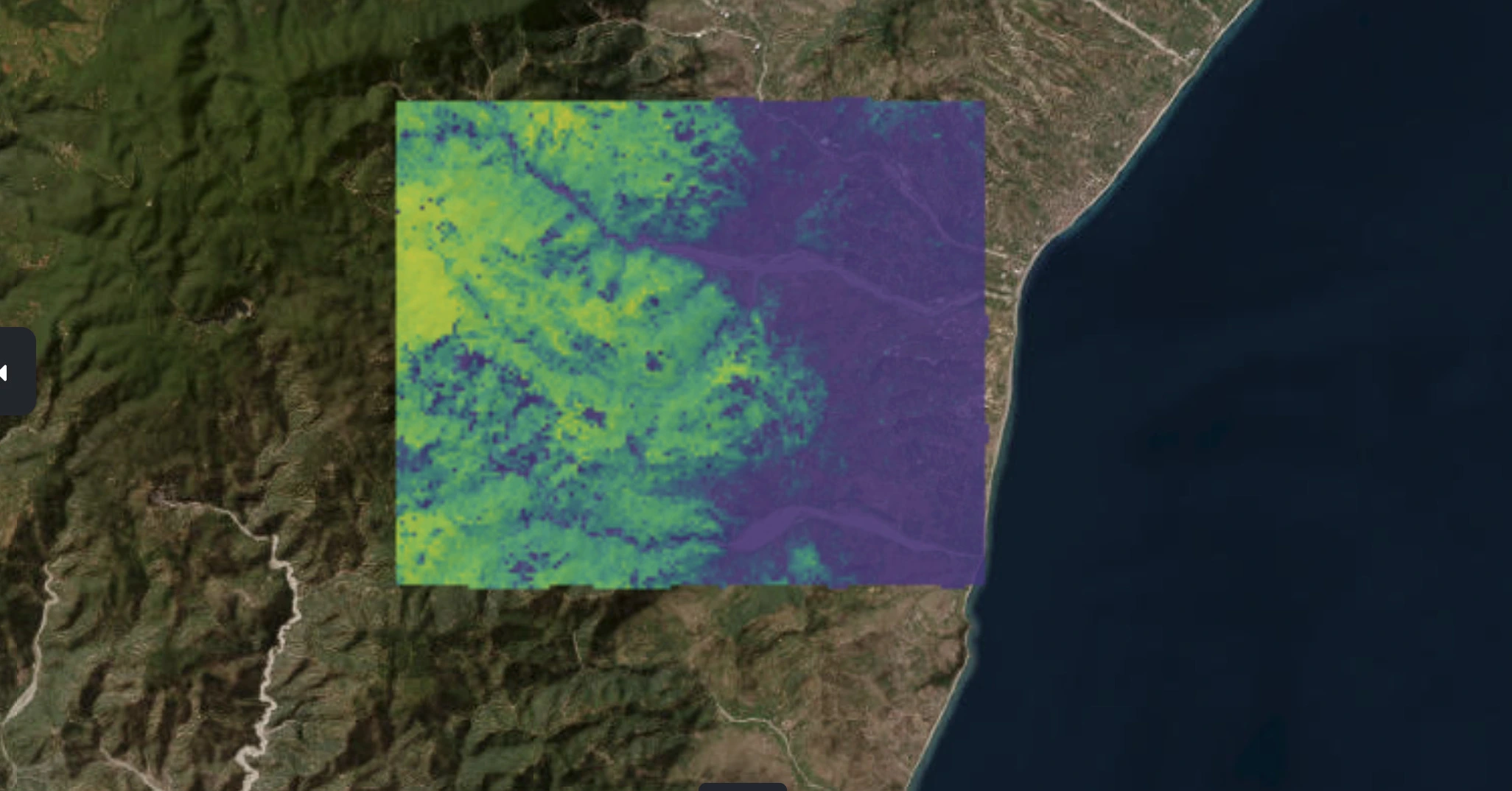
This approach allows precise monitoring of carbon storage in forests, agroforestry, and other land-use types, supporting reliable MRV workflows. By translating satellite-derived data into actionable metrics, the layer enables robust carbon footprint evaluation, ensures transparency in carbon credit certification, and facilitates measurable climate impact for companies advancing their net zero strategies.
IPCC-based fire risk layer for environmental risk assessment
The IPCC-based fire risk layer by Latitudo 40 provides a geospatial tool for assessing wildfire hazards that could compromise carbon storage and carbon sequestration in forested and burnable areas. While not publicly accessible, it is available through a custom application tailored to project-specific needs. The layer integrates geospatial data and earth observation, combining remote sensing inputs, topography, climate variables, and a physics-informed drought proxy derived from temperature and precipitation. Historical fire data is incorporated via machine learning to improve prediction of fire susceptibility, producing both annual hazard maps and scenario-based projections.
.webp)
Key specifications include:
- Input data: CHELSA Bioclim v2.1, ESA WorldCover 10 m, Copernicus DEM GLO-90, ERA5 climate variables, VIIRS Active Fire, CMIP6
- Algorithm: Physics-informed deep learning
- Spatial resolution: 500 m, global coverage
- Temporal resolution: Annual; historical maps up to the latest available year
- Future scenarios: CMIP6 SSP2-4.5 and SSP5-8.5 for 2030 and 2050
- Output formats: GeoTIFF; categorical, 2-class binary alert
- Automation & scalability: Fully automated; production time ~60 minutes per 100 km²
Applications include forest management, civil protection, climate adaptation planning, and screening for permanence risks in carbon and nature-based projects. By integrating IPCC-aligned climate projections with earth observation, the layer enables proactive mitigation of fire risk, ensuring the reliability of carbon credits and supporting long-term net zero strategies.
Integrating earth observation data into ESG reporting and carbon footprint evaluation
Integrating earth observation and geospatial data into ESG reporting and carbon footprint evaluation enables organizations to translate environmental performance into actionable insights.
Latitudo40’s Earth Data Insights (EDI) platform supports sustainability projects focused on carbon storage and carbon credits, allowing rapid access to verified KPIs derived from satellite monitoring and advanced analytics.

Through EDI, users can generate visual dashboards, charts, and interpretative data outputs that streamline corporate sustainability reporting and ensure alignment with regulatory and voluntary ESG frameworks. By leveraging remote sensing, organizations can quantify carbon sequestration, track changes in biomass, and assess project performance over time, providing auditable evidence for net zero strategies and enhancing transparency for stakeholders and investors.
.webp)
Case study – Carbon Trust project: satellite data for carbon credit transparency
Carbon Trust is a project promoted by ESA, the European Space Agency, developed by Latitudo40 to leverage geospatial data and earth observation to quantify forest carbon storage and monitor carbon sequestration risks. The system integrates AI-driven wildfire risk modeling and predictive carbon loss pipelines, providing a risk-adjusted, auditable framework for carbon credit transparency and ESG-aligned decision-making.
Project objectives and carbon sequestration monitoring approach
The Carbon Trust project aims to provide a predictive, risk-adjusted framework for monitoring forest carbon storage and carbon sequestration. Using user-defined Areas of Interest (AOI), the system integrates geospatial data pipelines, Above-Ground Biomass layers, and physics-informed AI wildfire risk models to quantify carbon stock, estimate potential losses, and project future scenarios under IPCC SSP2-4.5 and SSP5-8.5. Continuous temporal monitoring, carbon-at-risk maps, and KPI dashboards enable auditable insights, supporting forest carbon project developers, ESG analysts, and corporate carbon credit buyers in making informed, scalable net zero decisions.
_11zon.webp)
Experimental results for scalable net zero carbon markets
System was validated across five European pilot sites, spanning Mediterranean, alpine, coastal, and temperate ecosystems.
The physics-informed wildfire risk model achieved an AUC ≈ 0.70 on independent 2023–2024 test datasets. End-to-end validation produced carbon stock baseline maps (2020–2024), carbon-at-risk projections under SSP2-4.5 and SSP5-8.5, and comparative split-maps across scenarios.
KPIs derived from temperature and precipitation trends enable audit-grade monitoring of carbon storage and carbon sequestration. These results demonstrate scalable, risk-adjusted, and verifiable frameworks for net zero planning, supporting forest carbon credit developers, ESG analysts, and corporate buyers with robust, geospatially informed decision-making.
Unlocking Net Zero: Geospatial Data Empowering Carbon Credit Markets
Harnessing geospatial data and earth observation, Latitudo 40 transforms carbon storage and carbon sequestration into measurable impact. From predictive wildfire risk to KPI-driven dashboards, organizations can confidently advance net zero, enhance ESG transparency, and drive resilient, high-integrity carbon credit strategies.

.webp)


.webp)