.svg)


.svg)

Topic
Text
Asbestos Risk Insights (ARI) is an ESA-funded project by Latitudo 40 that leverages Earth Observation and AI to enable scalable asbestos risk management. By integrating multispectral and hyperspectral satellite data with multi-hazard modeling, ARI generates probabilistic maps and a Composite Priority Index to support detection, risk assessment, and ESG-aligned decision-making across large territories.
Article
Content
Introducing Asbestos Risk Insights (ARI): An ESA-Funded EO Platform for Asbestos Risk Management
Asbestos Risk Insights (ARI) is an ESA-funded project developed by Latitudo 40 to advance asbestos risk management through the integration of Earth Observation (EO) and geospatial data analytics. The initiative focuses on transforming satellite-derived information into operational intelligence for identifying and prioritizing asbestos-related risks across the built environment.
ARI combines multispectral and hyperspectral satellite data with AI-driven processing pipelines to generate probabilistic maps of asbestos-containing materials (ACMs) and assess their potential vulnerability. By embedding these outputs within a scalable geospatial framework, the platform enables continuous monitoring and supports evidence-based decision-making for public authorities, asset managers, and environmental operators.
The project’s objective is to validate a technically robust and economically viable EO-based service capable of supporting large-scale, standardized, and compliance-ready asbestos risk assessment workflows.
Asbestos Risk in Europe: Scale, Health Impact, and Regulatory Pressure
Despite a full ban implemented in 2005, asbestos remains a systemic risk across Europe due to its widespread historical use in the built environment.
The European Commission estimates that over 220 million building units were constructed before the ban, many of which still contain asbestos materials . This legacy exposure translates into a significant health burden: in 2019 alone, more than 70,000 deaths in the EU were attributed to past occupational exposure , with asbestos responsible for approximately 78% of occupational cancers.
Additionally, between 4.1 and 7.3 million workers are still exposed today, primarily in construction and renovation activities . These figures underpin increasing regulatory pressure, as EU policies, ranging from occupational safety directives to the Renovation Wave, aim to address asbestos as a critical barrier to safe, sustainable infrastructure.
The Hidden Risk of Asbestos Dispersion Driven by Climate and Extreme Events
Beyond its static presence in buildings, asbestos represents a dynamic environmental risk when exposed to climate stressors.
Extreme climate events, such as floods, earthquakes, and high-intensity windstorms, can accelerate material degradation and trigger the release of airborne fibers. This introduces a critical, yet often overlooked, pathway for asbestos dispersion, particularly in densely populated or vulnerable areas.
As climate risk intensifies across Europe, the interaction between aging asbestos-containing materials and environmental hazards increases the probability of large-scale exposure events, shifting asbestos management from a containment issue to a predictive, multi-hazard risk assessment challenge.
Limitations of Traditional Asbestos Detection and Monitoring Methods
Conventional asbestos detection relies predominantly on in-situ inspections, laboratory sampling, and manual surveys.
While accurate at the building level, these approaches present significant monitoring limitations when applied at scale.
They are:
- Time-intensive;
- Costly;
- Inherently fragmented.
This often results in incomplete datasets and outdated inventories.
Moreover, traditional workflows lack spatial continuity and do not support continuous monitoring or predictive analysis. This prevents stakeholders from prioritizing interventions across large territories or dynamically assessing risk evolution. As a result, current methodologies are poorly suited to address the growing need for scalable, data-driven asbestos risk management.
Current Earth Observation Approaches for Asbestos Detection: Progress and Limitations
Recent advances in Earth Observation have introduced geospatial data as a promising approach for large-scale asbestos detection, leveraging multispectral and hyperspectral imagery to identify material-specific spectral signatures.
However, operational constraints persist:
- Multispectral imagery (e.g., Sentinel-2)
- Spatial resolution: ~10 m
- High revisit frequency (~5 days)
- Limitation: insufficient spectral resolution for unambiguous asbestos identification
- Spectral ambiguity: different materials may exhibit similar spectral signatures, leading to false positives/negatives; conversely, asbestos-containing materials can present variable spectral responses depending on surface composition and degradation state
- Hyperspectral imagery (e.g., PRISMA, EnMAP)
- Spatial resolution: ~30 m
- High spectral resolution (hundreds of bands, VNIR–SWIR)
- Limitation: lower temporal frequency and limited coverage
- System-level gaps
- Fragmented data fusion pipelines
- Limited scalability and automation
- Lack of continuous monitoring frameworks
ARI addresses these monitoring limitations through a multi-sensor, AI-driven architecture enabling scalable and continuous asbestos detection.
ARI Methodology: Integrating Earth Observation and AI for Asbestos Detection
ARI implements a multi-layered Earth Observation asbestos detection framework that combines heterogeneous satellite data with AI-driven processing pipelines. The methodology is designed to balance spatial coverage, spectral sensitivity, and temporal frequency, enabling scalable AI asbestos mapping across large territories.
At its core, ARI adopts a hierarchical detection logic: large-scale screening is performed using continuous EO data streams, while targeted refinement leverages high spectral resolution imagery. This architecture supports the generation of per-pixel asbestos probability maps (P_ACM), integrating spectral matching techniques with machine learning models and uncertainty quantification.
.webp)
Multispectral Data for Large-Scale Screening
Multispectral imagery is used as the primary layer for continuous monitoring and broad-area detection.
- Source: Sentinel-2 (Copernicus Programme)
- Spatial resolution: up to 10 m (visible and NIR bands)
- Revisit time: ~5 days
- Spectral range: 13 bands (VNIR–SWIR)
- Function: baseline screening and temporal monitoring of material patterns
Hyperspectral Data for High-Confidence Detection
Hyperspectral imagery enables precise material discrimination through detailed spectral signatures.
- Sources: PRISMA (ASI), EnMAP (DLR)
- Spatial resolution: ~30 m
- Spectral resolution: hundreds of contiguous bands
- Spectral range: VNIR–SWIR (~400–2500 nm)
- Function: spectral validation and refinement of asbestos detection
This integrated approach enables ARI to overcome traditional EO monitoring limitations, ensuring both scalability and analytical precision.
Assessing Environmental Risk of Asbestos Dispersion Through Multi-Hazard Modeling
ARI extends beyond detection by implementing a multi-hazard modeling framework to quantify environmental risk associated with asbestos dispersion. The methodology integrates asbestos probability outputs (P_ACM) with geospatial hazard layers, including flood exposure, seismic intensity, and windstorm dynamics.
These datasets are spatially co-registered and processed to evaluate the likelihood of material degradation and fibre release under stress conditions. By incorporating hazard frequency, intensity, and proximity to exposed assets, ARI enables a dynamic assessment of asbestos dispersion pathways. This approach transforms static detection into a predictive environmental risk model, supporting prioritization and proactive intervention strategies.
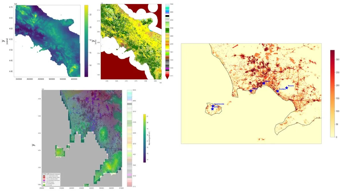
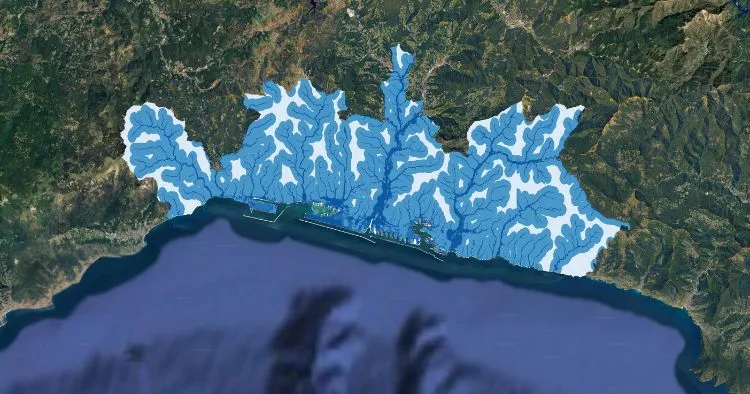
Flood Risk Assessment for Asbestos Dispersion Mapping
The flood risk asbestos model evaluates how hydrological events can trigger material degradation and fibre dispersion from asbestos-containing structures. It is based on the integration of dedicated geospatial flooding risk layers with ARI detection outputs.
Key technical components:
- Flood extent mapping: delineation of inundation-prone areas
- Recurrence intervals: frequency of flood events (return periods)
- Topographic factors: terrain slope and elevation (DEM-based)
- Hydrological exposure: proximity to rivers and drainage networks
- Spatial integration: overlay with P_ACM to identify high-risk assets
Seismic Risk Modeling for Asbestos Exposure and Structural Vulnerability
The seismic risk model evaluates how earthquake-induced structural stress can increase asbestos exposure and dispersion potential. It integrates geospatial seismic hazard data with ARI detection outputs to identify assets vulnerable to damage and fibre release.
Key technical components:
- Seismic hazard intensity: peak ground acceleration (PGA) and spectral acceleration metrics
- Event probability: return periods and historical earthquake catalogues
- Structural vulnerability proxies: building age, typology, and material degradation
- Exposure analysis: spatial correlation with populated and sensitive areas
- Validation benchmark: alignment with European seismic hazard models (e.g., EFEHR datasets)
.webp)
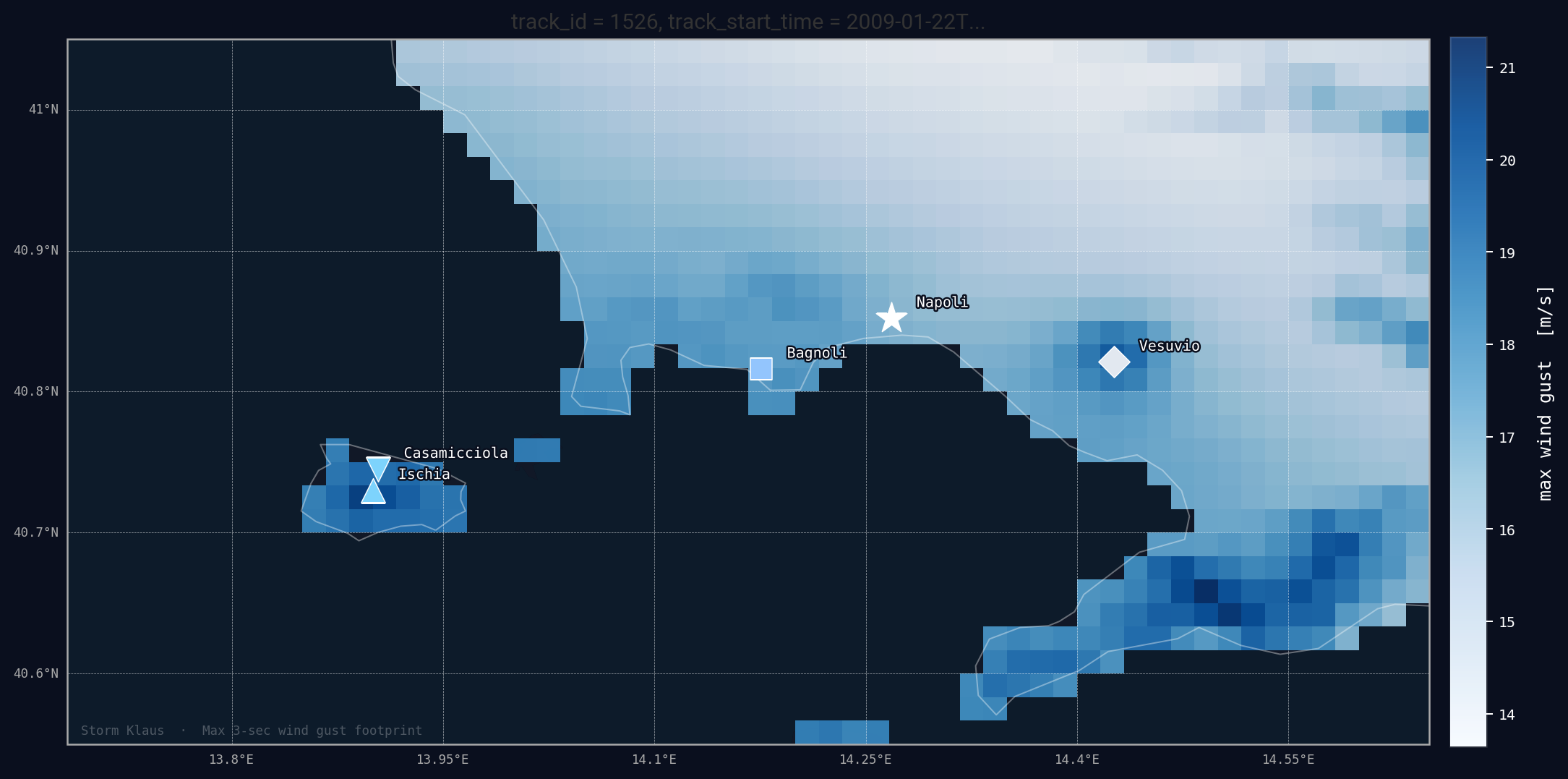
Windstorm Impact Analysis for Airborne Asbestos Dispersion
The wind risk model assesses the potential for airborne asbestos dispersion driven by extreme wind events, focusing on the interaction between structural degradation and atmospheric dynamics. It integrates historical storm data with geospatial exposure layers to identify high-risk zones.
Key technical components:
- Wind intensity metrics: peak wind speed and gust analysis from historical storm datasets
- Storm event frequency: recurrence and seasonal patterns of extreme wind events
- Land cover interaction: surface roughness influencing wind propagation
- Exposure factors: population density and proximity to sensitive receptors
- Spatial integration: overlay with P_ACM to identify assets at risk of airborne asbestos release
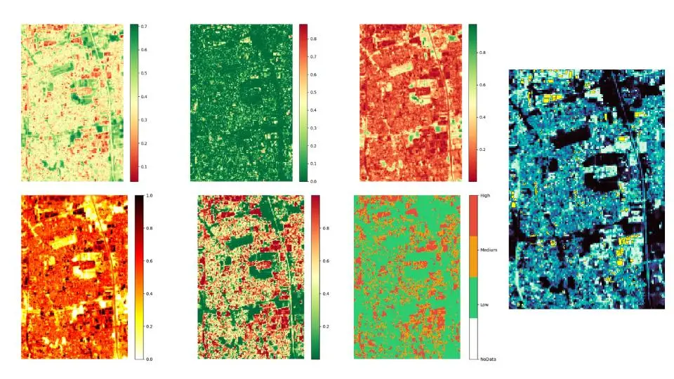
The Composite Priority Index (CPI): From Detection to Actionable Risk Intelligence
The Composite Priority Index (CPI) is the core analytical output of ARI, designed to translate detection results into actionable risk intelligence. It aggregates multiple geospatial inputs into a standardized, asset-level risk score:
- Asbestos probability (P_ACM): per-pixel likelihood of asbestos presence
- Multi-hazard exposure: flood, seismic, and windstorm risk layers
- Structural vulnerability factors: building characteristics and degradation proxies
- Socio-environmental exposure: population density and proximity to sensitive receptors
The CPI enables spatial prioritization by ranking assets based on dispersion likelihood and impact, supporting data-driven inspection planning, remediation strategies, and ESG-aligned risk management.
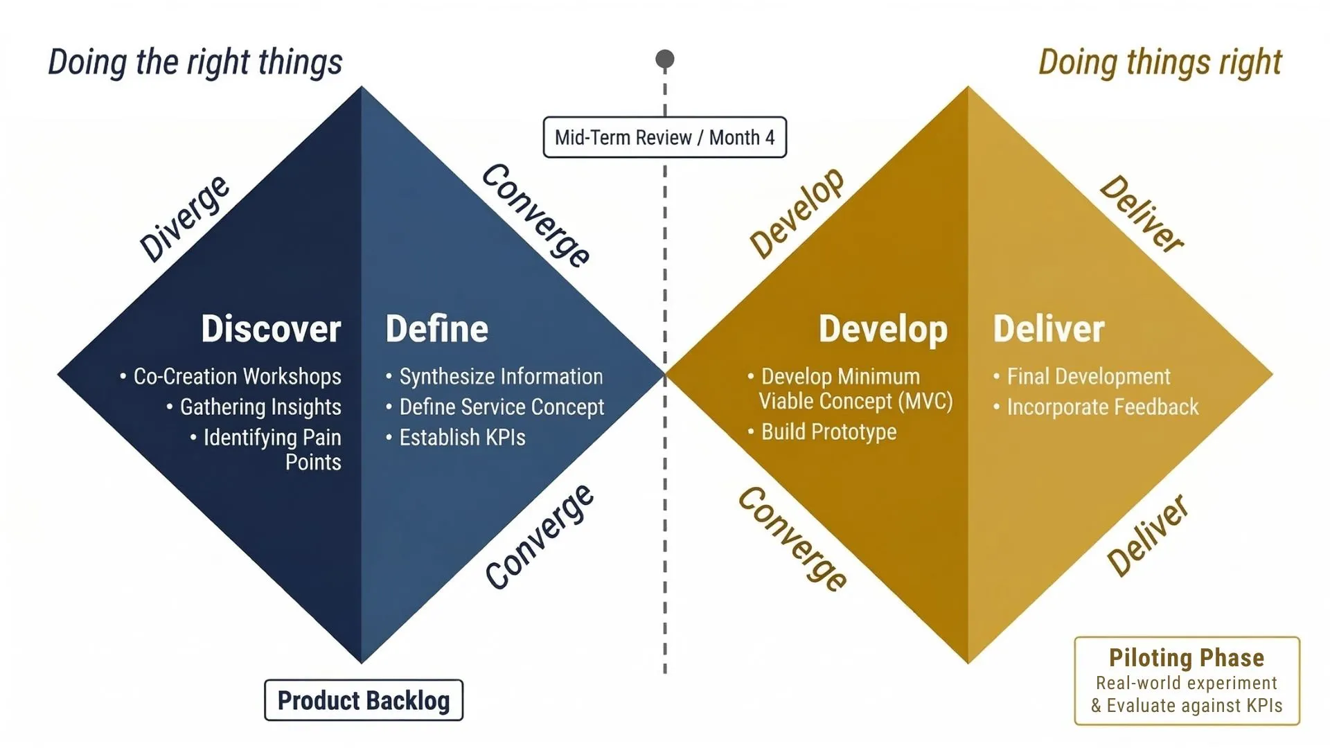
Next Steps: From Mid-Term Validation to Pilot Deployment
Following the Mid-Term Review, ARI transitions from modular validation to full system integration and operational deployment. The next phase focuses on consolidating data ingestion pipelines, AI detection modules, and multi-hazard components into a unified, cloud-based architecture.
Key activities include refining model performance, improving user interface and data visualization, and validating outputs through real-world pilot scenarios. The pilot phase will test system reliability against defined KPIs, such as accuracy, processing time, and usability, ensuring the platform meets operational requirements for large-scale asbestos risk management and decision-support applications.
Operational Use Cases: Applying EO-Based Asbestos Risk Intelligence Across Sectors
Public Authorities: Urban Risk Mapping and Intervention Planning
Municipalities and regional agencies use ARI to generate territory-wide asbestos risk maps, enabling prioritization of inspections and allocation of remediation budgets. The integration of hazard layers supports civil protection planning and policy enforcement.
Asset Managers: Portfolio Risk Assessment and ESG Compliance
Corporate stakeholders leverage ARI to screen large real estate portfolios, identifying high-risk assets and integrating standardized indicators into ESG and CSRD reporting workflows. This enables scalable due diligence and risk-informed investment decisions.
Remediation Operators: Workflow Optimization and Site Prioritization
Environmental remediation firms use ARI outputs to optimize intervention sequencing, focusing on sites with the highest dispersion risk. This improves operational efficiency, reduces unnecessary inspections, and ensures compliance with safety and regulatory requirements.

.webp)


.webp)