.svg)


.svg)
.webp)
Topic
Text
Artificial intelligence is transforming emergency management by enabling predictive risk assessment, data-driven decision support, and optimized emergency response. By integrating AI with geospatial data, public authorities can better anticipate disasters, protect public health, and improve operational efficiency. Initiatives such as MEDAIGENCY and the AI4PURPOSE Hackathon demonstrate how applied innovation can strengthen climate resilience and disaster management across Europe and the Mediterranean.
Article
Content
Emergencies in Europe: a growing challenge for disaster management

Europe is experiencing a steady escalation of climate- and hazard-driven emergencies, increasing pressure on disaster management and emergency management systems.
According to UN and EU data, heatwaves alone caused more than 60,000 deaths in Europe in a single year, accounting for around 95% of fatalities linked to climate-related extreme events.
Flooding represents the most severe economic threat: over the past 30 years, floods have affected millions of people across Europe and generated over €170 billion in economic losses, damaging critical infrastructure and urban systems.
In parallel, seismic risk remains a structural factor in several European regions, exposing dense populations and strategic assets.
The growing frequency, intensity, and spatial complexity of these events are transforming emergencies from isolated crises into systemic challenges, requiring more advanced, predictive, and data-driven approaches to disaster management at regional and national scale.
Health systems under stress during emergencies
Large-scale emergencies place public health systems under acute and prolonged stress, challenging their ability to deliver timely and effective emergency response. Climate-driven events such as heatwaves, floods, and earthquakes generate sudden surges in hospital admissions, while simultaneously disrupting healthcare infrastructure, supply chains, and workforce availability.
The main causes of stress on public health systems during emergencies include:
- Sudden peaks in healthcare demand, exceeding hospital and emergency department capacity;
- Infrastructure vulnerability, including damage to hospitals, clinics, and transport networks;
- Limited situational awareness, delaying coordinated emergency response across territories;
- Resource shortages, from medical staff to critical equipment and pharmaceuticals;
- Fragmented data flows, hindering real-time decision-making and inter-agency coordination;
These factors expose structural limits in traditional emergency management approaches, particularly when crises evolve rapidly across large geographic areas. Strengthening emergency response in public health therefore requires integrated, data-driven systems capable of anticipating impacts, prioritizing interventions, and supporting authorities with actionable intelligence before, during, and after emergencies.
The need for data-driven emergency management in healthcare
Effective emergency response in public health increasingly depends on the ability to transform heterogeneous data into operational intelligence. Traditional healthcare emergency management models rely on reactive workflows and fragmented information, limiting their capacity to anticipate cascading impacts during complex crises. As climate-related emergencies become more frequent and spatially widespread, public health authorities must integrate epidemiological data with environmental, infrastructural, and demographic indicators to support timely decisions.
Data-driven emergency management enables healthcare systems to forecast demand surges, identify vulnerable populations, and prioritize interventions at territorial scale. By combining predictive analytics with real-time monitoring, authorities can improve resource allocation, coordinate multi-agency responses, and reduce preventable health outcomes. This approach shifts emergency response from a purely reactive model to a proactive and adaptive framework, where evidence-based insights support preparedness, response, and recovery. In this context, advanced analytics and geospatial intelligence become critical enablers for resilient public health systems operating under increasing emergency pressure.
Artificial intelligence for emergency management
Artificial intelligence is increasingly recognized as a strategic enabler for modern emergency management, supporting public authorities in handling complex, fast-evolving crises that impact public health and critical services. By augmenting traditional emergency response systems, AI enables faster analysis, improved coordination, and more informed decision-making across the full emergency lifecycle.
In the context of emergency management, AI applications focus on several key operational areas:
- Risk assessment and scenario modeling, to anticipate the health and territorial impacts of extreme events;
- Decision support for emergency management authorities, enhancing situational awareness and response coordination;
- Resource allocation and operational optimization, ensuring critical assets are deployed where and when they are most needed;
By processing large volumes of heterogeneous data in near real time, AI helps shift emergency response from reactive intervention to proactive management. This capability is particularly relevant for public health systems, where timely, data-driven decisions can significantly reduce response times and mitigate health outcomes during large-scale emergencies.
Risk assessment and scenario modeling for disaster preparedness
Risk assessment plays a critical role in strengthening disaster preparedness and improving emergency response outcomes, especially in the public health domain. As emergencies increasingly affect large and densely populated areas, preparedness strategies must account not only for hazard occurrence but also for exposure, vulnerability, and response capacity.
Artificial intelligence supports scenario modeling by integrating multiple variables, including climate indicators, land use, population density, age distribution, and critical infrastructure. In Europe, flood-prone areas often overlap with urban zones hosting millions of residents, while seismic risk maps indicate that a significant share of the population lives in regions exposed to moderate-to-high earthquake hazard. Heat-related risk models further show that urban heat islands can increase local surface temperatures by several degrees Celsius, amplifying health risks during extreme events.
.webp)
Since 2022 the area has been affected by over 10.000 seismic events, affecting millions of inahbitants.
AI-driven scenario simulations allow emergency management authorities to evaluate how different hazard intensities may affect healthcare demand, accessibility to services, and response times. For public health systems, this enables proactive planning, such as identifying priority intervention areas, estimating emergency admissions, and testing response capacity under multiple scenarios. By supporting evidence-based preparedness, AI enhances the resilience and effectiveness of emergency response strategies before crises escalate.
AI-powered decision support for emergency management authorities
AI-powered decision support systems are transforming how emergency management authorities respond to complex crises, enabling faster, evidence-based decisions that directly impact public health outcomes. By processing large volumes of real-time data—from meteorological sensors, satellite imagery, population movement, and hospital admissions—AI algorithms can identify emerging hotspots and predict areas of critical need before emergencies escalate.
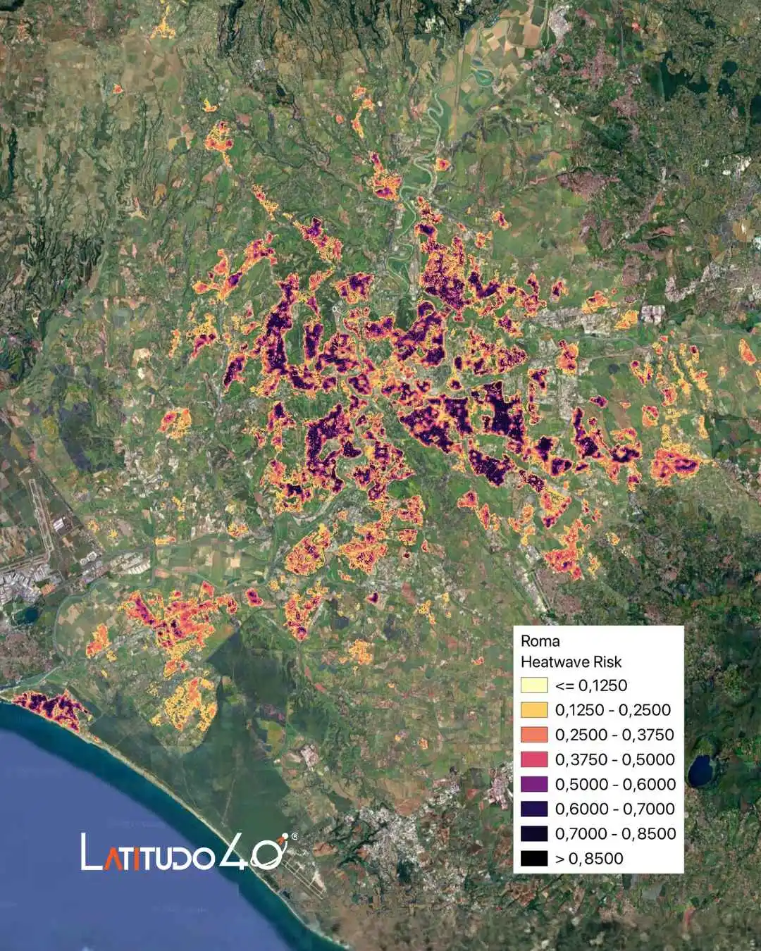
For example, during flood events, AI can combine rainfall forecasts with topography and infrastructure maps to pinpoint neighborhoods at highest risk, allowing emergency services to pre-position medical teams and resources efficiently. Similarly, in heatwave scenarios, predictive models can highlight urban districts with high vulnerability due to population density and limited cooling infrastructure, supporting targeted public health advisories.
Integrating AI into emergency management also facilitates multi-agency coordination. Decision support dashboards consolidate data from civil protection, healthcare networks, and municipal authorities, reducing response times and enabling synchronized interventions.
By offering probabilistic forecasts, actionable insights, and scenario-based guidance, AI helps authorities anticipate healthcare demand surges, optimize resource allocation, and prioritize interventions. This approach strengthens emergency response capabilities, mitigates preventable health impacts, and enhances the resilience of public health systems facing increasingly frequent and severe crises.
Resource allocation and operational optimization during emergencies
Efficient resource allocation is a critical determinant of effective emergency response, particularly in public health crises. AI-driven tools enable authorities to dynamically match available resources—such as medical personnel, ambulances, hospital beds, and relief supplies—to evolving needs across affected regions. By analyzing real-time data on population density, infrastructure accessibility, and hazard exposure, AI models can identify priority areas for intervention, reducing delays and optimizing coverage.
During flood or seismic events, for instance, predictive algorithms can recommend the optimal deployment of emergency medical teams, ensuring that high-risk zones receive timely support. Similarly, in heatwave scenarios, AI can help target cooling centers, allocate mobile health units, and prioritize vulnerable populations such as the elderly or those with chronic illnesses.
Operational optimization is further enhanced through the integration of multi-layer geospatial data, which provides a detailed understanding of urban topology, transport networks, and potential bottlenecks. This enables scenario simulations that test different deployment strategies, improving decision-making under time pressure.
By combining predictive analytics with geospatial intelligence, AI ensures that public health systems operate at maximum efficiency during crises, reducing avoidable morbidity and mortality while enhancing overall emergency response resilience.
Geospatial intelligence for climate resilience and emergency response
Geospatial intelligence (GI) is becoming a cornerstone of modern emergency management, particularly for enhancing climate resilience and public health protection. By integrating satellite imagery, remote sensing data, and geographic information systems (GIS), authorities can obtain detailed, multi-layered insights into hazard exposure, population distribution, and critical infrastructure. This enables more precise and timely emergency response planning.
For instance, satellite-derived datasets on flood risk, urban heat islands, tree cover, and building height allow predictive models to identify neighborhoods most vulnerable to climate extremes. Heatwave analysis can leverage land surface temperature maps to target interventions where urban heat amplifies health risks, while flood simulations benefit from high-resolution topography and hydrological data to optimize evacuation routes and resource deployment.
Geospatial intelligence also supports multi-scenario simulations, allowing emergency management teams to anticipate cascading impacts across sectors, from healthcare demand to transport and energy networks. By overlaying demographic, environmental, and infrastructural layers, authorities can prioritize interventions and improve situational awareness, reducing response times and mitigating preventable losses.
Moreover, combining GI with artificial intelligence enhances decision-making by automating the extraction of actionable insights from complex datasets. Predictive analytics can highlight emerging threats, quantify potential impacts, and optimize operational strategies. For public health systems and civil protection agencies, this approach transforms static maps into dynamic, evidence-based tools that improve preparedness, response, and resilience against climate-driven emergencies.
MEDAIGENCY: AI and geospatial data for emergency management in the Mediterranean
The Mediterranean region is particularly exposed to climate-related hazards, including heatwaves, flooding, wildfires, and seismic events, which pose significant challenges for emergency management and public health systems. MEDAIGENCY is a cross-border initiative designed to address these challenges by leveraging artificial intelligence and geospatial data to support more effective emergency response and preparedness across the region.
.webp)
The project integrates satellite-derived environmental indicators, territorial data, and AI-driven analytics into interoperable decision-support tools tailored for public authorities and civil protection agencies. By combining climate variables, urban characteristics, and population exposure, MEDAIGENCY enables a more comprehensive assessment of risk and vulnerability at local and regional scale.
A key objective of MEDAIGENCY is to enhance coordination among emergency management stakeholders by providing shared, data-driven insights that improve situational awareness and response planning. The platform supports the transition from reactive emergency response to proactive risk management, enabling authorities to anticipate impacts, prioritize interventions, and optimize resource deployment. In a region characterized by high environmental variability and densely populated coastal and urban areas, AI-powered geospatial intelligence represents a critical asset for strengthening resilience and protecting public health.
Supporting public authorities with AI-driven geospatial decision tools
AI-driven geospatial decision tools are enabling public authorities to manage emergencies with greater accuracy, speed, and coordination. By integrating satellite data, environmental indicators, and territorial information into unified platforms, these tools provide a shared operational picture that supports emergency management across institutions and administrative levels.
Through advanced analytics, authorities can monitor evolving hazards, assess exposure, and evaluate potential impacts on critical infrastructure and public health in near real time. Multi-layer geospatial intelligence allows decision-makers to compare scenarios, prioritize high-risk areas, and plan targeted emergency response actions based on objective evidence rather than fragmented inputs.
Within MEDAIGENCY, these capabilities support civil protection agencies, health authorities, and local governments in aligning preparedness and response strategies. AI-driven tools enhance interoperability, reduce information asymmetries, and improve coordination during crises, strengthening the overall effectiveness of emergency management systems in complex, multi-hazard environments.
AI4PURPOSE Hackathon: innovation for emergency management
The AI4PURPOSE Hackathon is a two-day innovation sprint designed to accelerate the adoption of artificial intelligence in emergency management and public health. Organized within the MEDAIGENCY project and co-funded by the Interreg NEXT MED Programme, the initiative brings together students, professionals, researchers, and innovators to develop AI-powered Proofs of Concept addressing real emergency response challenges.
By working on geospatial and environmental data, participants will design data-driven solutions aimed at improving disaster management, decision support, and operational readiness for public authorities. The most promising solution will be evaluated for potential integration into the MEDAIGENCY ecosystem, bridging experimentation and real-world deployment.
Key information at a glance:
- Event: AI4PURPOSE Hackathon
- Focus: AI for emergency management and public health
- Dates: 7–8 February
- Location: Apple Developer Academy, Naples
- Partners: Latitudo40, Soresa Spa, Codemotion
- Outcome: AI-powered prototypes for MEDAIGENCY
The hackathon represents a concrete opportunity to turn innovation into impact within the emergency management domain.
Do you want to know more and register to the AI4PURPOSE hackathon?
Explore all details here: https://go.codemotion.com/hackathon-ai4purpose/
Discover everything about MEDAIGENCY here: https://www.interregnextmed.eu/project-page/medaigency/about/
.webp)

.webp)