.svg)


.svg)

Topic
Text
The STREAMO project, supported by the European Space Agency and developed by Latitudo40 with Stratobotic, integrates HAPS technology into operational Earth Observation workflows. Using CubeHAPS stratospheric platforms, STREAMO delivers RGB + DEM, multispectral, and thermal analysis-ready data layers on EarthDataPlace for environmental, urban, industrial, and ESG applications.
Article
Content
STREAMO Project Overview: Objectives, Partners and Applications
The STREAMO project is an ESA Earth Observation project focused on integrating stratospheric EO data into operational geospatial workflows. It leverages imagery acquired from HAPS platforms to generate standardized, analysis-ready data layers.
By bridging acquisition and delivery through scalable infrastructures, STREAMO supports advanced Earth Observation applications and drives geospatial data innovation across environmental monitoring, infrastructure analysis, and ESG-related use cases.
Key Partners: Latitudo40, Stratobotic and ESA
The STREAMO project is built on a complementary partnership integrating acquisition, processing, and programmatic support within an ESA Earth Observation project framework:
- Latitudo40: Develops processing pipelines and transforms stratospheric EO data into standardized, analysis-ready geospatial products, enabling scalable Earth Observation applications.
- Stratobotic: Provides data acquisition capabilities through HAPS platforms, ensuring high-resolution, persistent stratospheric EO data collection over targeted areas.
- European Space Agency: Supports the STREAMO project within its Earth Observation programme, fostering geospatial data innovation and facilitating the integration of emerging technologies into operational EO services.
Project Goals and Earth Observation Applications
The STREAMO project, within the framework of an ESA Earth Observation project, aims to operationalize stratospheric EO data by transforming high-resolution acquisitions into scalable geospatial products for advanced Earth Observation applications.
Key objectives:
- Standardize stratospheric EO data into analysis-ready formats
- Integrate HAPS-derived datasets into operational geospatial workflows
- Bridge the gap between satellite coverage and airborne precision
- Enable scalable access via interoperable data platforms
Earth Observation applications:
- Environmental monitoring: vegetation health, land use change, biodiversity assessment
- Urban analytics: high-resolution mapping, urban heat island detection, infrastructure planning
- Industrial monitoring: thermal analysis for emissions and energy efficiency
- Risk and ESG analysis: support for data-driven sustainability strategies
Operating at altitudes of ~18–25 km, HAPS platforms enable persistent monitoring with higher temporal resolution than satellites and broader coverage than drones, strengthening geospatial data innovation and unlocking new capabilities for continuous Earth Observation.
.webp)
High-Altitude Pseudo-Satellites: A New Earth Observation Paradigm
High-Altitude Pseudo-Satellites (HAPS) are unmanned platforms operating in the stratosphere, typically at altitudes of 18–25 km, well above commercial air traffic and weather systems. Positioned between satellites and drones, HAPS enable a new class of Earth Observation by combining high-resolution EO data with persistent monitoring capabilities.
Unlike orbital systems, which are constrained by revisit times, HAPS can remain over a target area for extended periods—ranging from several hours to multiple days—allowing continuous acquisition of stratospheric imagery. This enables near real-time monitoring with significantly higher temporal resolution.
Key characteristics of HAPS Earth Observation include:
- Spatial resolution comparable to airborne systems (sub-meter level)
- Persistent monitoring EO over localized Areas of Interest
- Reduced latency in data acquisition and delivery
- Flexible deployment for targeted missions
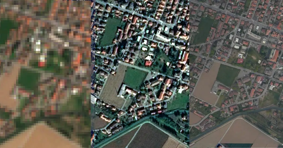
Stratospheric Imagery as a Complement to Satellite Data
By bridging the gap between satellite-scale coverage and drone-level detail, High-Altitude Pseudo-Satellites are redefining how high-resolution EO data is captured and operationalized across environmental, urban, and industrial applications.
Stratospheric imagery acquired through High-Altitude Pseudo-Satellites complements satellite data by addressing key limitations in temporal resolution and tasking flexibility. While satellites provide global coverage with revisit times ranging from hours to days, HAPS platforms operating at 18–25 km enable persistent monitoring EO over specific Areas of Interest.
This integration enhances Earth Observation workflows by combining:
- Satellite-scale coverage for regional context
- HAPS Earth Observation for localized, high-frequency acquisition
- High-resolution EO data at sub-meter level
Stratospheric imagery is particularly effective in scenarios requiring continuous observation, such as infrastructure monitoring, environmental change detection, and emergency response. By reducing latency and enabling targeted data collection, HAPS act as a complementary layer within multi-source EO architectures, improving both the accuracy and timeliness of geospatial analysis.
Stratobotic and CubeHAPS Technology
Stratobotic is a technology provider specialized in stratospheric robotics and High-Altitude Pseudo-Satellites, developing platforms for advanced Earth Observation and near-space applications. Within STREAMO, it enables HAPS Earth Observation through its CubeHAPS system.
CubeHAPS key capabilities:
- Operates at ~18–25 km altitude, above weather systems and air traffic
- Supports persistent monitoring EO over targeted Areas of Interest
- Ensures stable acquisition of high-resolution EO data with low atmospheric interference
- Enables flexible mission planning and rapid deployment
By leveraging modular and scalable architectures, CubeHAPS enhances the quality and continuity of stratospheric imagery, positioning High-Altitude Pseudo-Satellites as a complementary asset within advanced Earth Observation workflows.
STREAMO Data Layers on EarthDataPlace
The STREAMO project delivers three analysis-ready EO data layers available on EarthDataPlace, designed to support scalable geospatial workflows through an EO data marketplace.
Available geospatial data layers:
- RGB + DEM: high-resolution optical imagery integrated with elevation data
- Multispectral: multi-band data for environmental and land analysis
- Thermal: surface temperature measurements for climate and industrial insights
Generated from stratospheric acquisitions, these EarthDataPlace datasets provide standardized, interoperable inputs for advanced Earth Observation applications.
RGB + DEM Layer: High-Resolution Terrain and Mapping Insights
RGB + DEM data combines high-resolution optical imagery (Red, Green, Blue bands) with a Digital Elevation Model (DEM) to deliver integrated 2D and 3D geospatial information. This dataset supports precise terrain representation and spatial analysis.
Key components:
- RGB imagery: detailed visual mapping at sub-meter resolution
- DEM: elevation data enabling vertical accuracy and surface modeling
Capabilities:
- 3D mapping geospatial environments
- Advanced terrain analysis satellite workflows
- Improved feature extraction for infrastructure and land assessment
This fusion enhances digital elevation model EO applications by providing both spectral and topographic context in a single dataset.

Key Applications and Use Cases
Key applications of RGB DEM data leverage the integration of optical imagery and digital elevation model EO for high-precision geospatial analysis:
- 3D mapping geospatial: generation of detailed surface models for urban planning and infrastructure design
- Terrain analysis satellite: slope, elevation, and morphology assessment for risk and land management
- Infrastructure monitoring: asset mapping and change detection at sub-meter resolution
- Environmental analysis: watershed modeling and landform classification
This dataset enhances accuracy and consistency in terrain-based Earth Observation applications.
Thermal Layer: Surface Temperature and Climate Intelligence
Thermal EO data measures emitted infrared radiation to derive land surface temperature, enabling quantitative analysis of heat distribution across natural and built environments.
Key characteristics:
- Thermal satellite data: surface temperature mapping with fine spatial detail
- Detection of temperature gradients and anomalies
- Day/night acquisition capability
Core value:
- Supports climate monitoring EO
- Enables urban heat island analysis
- Provides actionable inputs for environmental and industrial assessments

Key Applications
Key applications of thermal satellite data leverage high-resolution land surface temperature measurements for advanced geospatial analysis:
- Urban heat island analysis: identification of hotspots and temperature differentials in dense urban areas
- Climate monitoring EO: detection of thermal anomalies and long-term trends
- Industrial monitoring: heat loss analysis and emission hotspot detection
- Energy efficiency: assessment of building performance and infrastructure
-
These datasets enhance temporal consistency and support data-driven environmental and operational decision-making.
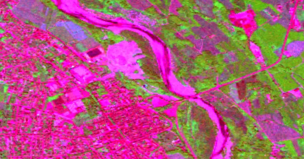
Multispectral Layer: Advanced Environmental Monitoring
Multispectral data captures reflectance across multiple spectral bands (e.g. visible and near-infrared), enabling detailed analysis of surface properties beyond standard imagery.
Key characteristics:
- Multispectral satellite data: multi-band acquisition for spectral analysis
- Supports NDVI analysis for vegetation health
- Enables classification of land cover and surface materials
Core value:
- Advanced vegetation monitoring EO
- Detection of environmental changes
- Actionable insights for ESG satellite data applications
Key Applications
Key applications of multispectral satellite data leverage spectral analysis to extract environmental and land-use insights:
- NDVI analysis: assessment of vegetation health, stress, and productivity
- Vegetation monitoring EO: crop monitoring, forestry management, biodiversity tracking
- Land use classification: identification of surface types and change detection over time
- ESG satellite data: support for sustainability reporting and environmental risk assessment
These datasets enable higher temporal resolution and more targeted monitoring compared to traditional satellite systems.
Strategic Value of EarthDataPlace Integration
The integration of STREAMO datasets into EarthDataPlace aligns with the vision of Latitudo40 to advance the democratization of EO data. By making stratospheric and satellite-derived products accessible through a centralized platform, users can access high-resolution datasets without managing complex acquisition or processing infrastructures. This approach lowers technical barriers and expands satellite data access to a broader range of stakeholders.
Scalable and Interoperable Data Distribution
EarthDataPlace functions as a scalable geospatial data platform, enabling standardized distribution of STREAMO data layers. Datasets are delivered as analysis-ready products, ensuring:
- interoperability with existing EO workflows
- integration via APIs into enterprise systems
- consistency across multiple geographic contexts
This infrastructure supports efficient data ingestion and accelerates time-to-insight for advanced Earth Observation applications.
Supporting ESG and Data-Driven Decision Making
By providing structured and reliable datasets, EarthDataPlace strengthens the adoption of ESG data solutions. Organizations can integrate STREAMO layers into environmental monitoring, risk assessment, and sustainability reporting processes.
The availability of high-frequency, high-resolution data enables:
- improved transparency in ESG metrics
- continuous monitoring of environmental indicators
- data-driven decision-making at operational and strategic levels
In this context, EarthDataPlace acts as a key enabler for scaling the impact of Earth Observation across industries.
All layers are coming soon on Latitudo 40’s EarthDataPlace. Follow us on social media for all updates on the official release.

.webp)


.webp)