
.svg)


.svg)
Topic
Text
Discover how Geospatial Intelligence Platforms powered by earth observation data are transforming ESG reporting and ESG strategies. From monitoring environmental variables to predicting future scenarios, these SaaS solutions enable data-driven ESG policies and foster climate resilience. Learn how Latitudo40’s Earth Data Insights is reshaping sustainability decision-making.
Article
Content
Decision-Making in ESG Management and Corporate Responsibility
At the core of ESG management lies a clear ambition: building a more sustainable and livable future rather than depleting the planet’s resources and compromising human well-being. Modern ESG policies are designed not simply as compliance tools but as strategic frameworks that guide organizations toward responsible growth. By integrating environmental stewardship, social responsibility, and transparent governance, companies can reduce their ecological footprint while contributing positively to society.
Effective ESG strategies enable organizations to anticipate climate risks, preserve natural resources, and foster resilience in communities. For businesses, this means leveraging reliable data and structured methodologies to ensure that every action aligns with the broader goal of sustainability.
In this context, ESG reporting becomes more than a disclosure requirement: it is a way to measure progress, communicate impact, and engage stakeholders around a shared vision of long-term prosperity. By embedding sustainability into corporate governance, companies are not only protecting their own continuity but also contributing to safeguarding ecosystems, ensuring healthier urban environments, and ultimately improving quality of life for future generations.
In the following sections we expose the major critical issues in ESG management, before introducing, as a potential solution, the concept of Geospatial Intelligence Platforms: tools able to provide robust insights built on satellite data driven methodologies and to solicit participative governance and stakeholder engagement.
We conclude our article by presenting you how Latitudo 40 is approaching Geospatial Intelligence Platforms by developing Earth Data Insights: a revolutionary tool designed to set a major paradigm shift in how communities and organizations are designing ESG policies and interventions.
Critical Issues in ESG Reporting for Environmental Management
One of the greatest challenges in ESG reporting relates to the environmental dimension, where organizations must measure and demonstrate the impact of their activities on ecosystems and climate. Despite the growing demand for transparency, many companies struggle with fragmented, non-standardized, and sometimes unreliable datasets. This limitation often results in inconsistent ESG policies and prevents stakeholders from comparing performance across industries and regions.
Accurate monitoring of environmental variables is a prerequisite for sound ESG strategies, yet traditional data sources are frequently insufficient. Reports may rely on estimates, outdated records, or voluntary disclosures that lack external validation. As a result, decision-makers face uncertainty when evaluating which interventions can truly enhance sustainability or strengthen climate resilience.
This is where earth observation plays a transformative role. Satellite imagery and geospatial data offer a standardized, science-based alternative to conventional monitoring methods. With consistent coverage at different scales, earth observation enables companies to assess parameters such as land use change, vegetation cover, urban heat, or flood risks, providing objective insights into environmental performance. Integrating these data into ESG reporting allows organizations to move from static and retrospective assessments to dynamic, evidence-based evaluations.
However, access to data alone is not sufficient. To unlock its full potential, businesses need platforms capable of processing satellite information and translating it into actionable insights. Only then can environmental monitoring become a reliable foundation for ESG policies, guiding investments and interventions that preserve natural resources, reduce risks, and deliver tangible progress toward a sustainable future.
Assessing ESG Strategies with Data-Driven Simulation Models
A key limitation in current ESG strategies is the inability to anticipate the long-term effects of interventions. Organizations often design environmental initiatives without the analytical tools needed to forecast their outcomes, which can result in ineffective actions, time and money loss. This uncertainty undermines the credibility of ESG policies and weakens the capacity to deliver measurable improvements in sustainability and climate resilience.
Simulation models offer a robust methodology to address this gap. By combining historical datasets, geospatial information, and predictive analytics, these models allow organizations to test different scenarios before implementing them in practice. For example, urban planners can simulate the effect of increasing tree cover on reducing urban heat islands, while utilities can evaluate the impact of flood mitigation projects on risk reduction. This approach enables decision-makers to assess not only the direct environmental benefits but also the potential economic and social outcomes of their strategies.
The integration of earth observation data significantly enhances the reliability of these models. Satellite imagery provides objective, spatially consistent inputs that reflect real-world conditions, such as land surface temperature, carbon storage, or flood risk exposure. Feeding these indicators into simulation frameworks helps generate “what-if” analyses that reveal the consequences of different policy choices.
By adopting data-driven simulation models, organizations can shift from reactive ESG reporting to proactive planning. This capability makes it possible to prioritize the most impactful actions, allocate resources more efficiently, and demonstrate accountability to stakeholders. Ultimately, simulation-based methodologies represent a crucial step in evolving ESG policies from aspirational commitments to scientifically grounded strategies that deliver tangible progress toward a sustainable future.
Streamlining ESG Reporting for Stakeholders Engagement
For ESG policies to be effective, they must be supported by transparent communication and active stakeholder participation. Yet, one of the recurring challenges in ESG reporting is the difficulty of sharing complex environmental data in formats that are accessible and actionable for diverse audiences, ranging from investors and regulators to local communities. Fragmented reporting processes often create information asymmetries, reducing trust and slowing down the implementation of sustainable initiatives.
To strengthen ESG strategies, organizations need reporting mechanisms that not only ensure compliance but also foster inclusiveness. A streamlined approach to disclosure allows stakeholders to understand the rationale behind corporate actions, monitor progress and provide meaningful feedback. This participatory model of governance contributes to building stronger relationships with stakeholders while aligning corporate activities with broader societal goals such as climate resilience and environmental stewardship.
Innovative frameworks, such as Urban Living Labs, illustrate the value of collaborative models. By creating shared environments where data, insights, and proposed interventions are openly discussed, these initiatives make it possible to test solutions, integrate multiple perspectives, and accelerate consensus around sustainable choices. Embedding such practices into ESG reporting can transform sustainability disclosure into a dynamic process of citizens and stakeholders engagement rather than a static compliance exercise.
In this framework lies the foundation for the transition from the concept of “government” to that of “governance”. While “government” refers to a top-down model of enforcing ESG decisions and policies, “governance” emphasizes citizens engagement, where decisions are co-designed and shared through a collaborative approach. This shift makes actions more effective and better aligned with the real needs of communities.
The Role of SaaS in Building Geospatial Intelligence Platforms
The growing complexity of ESG strategies demands digital solutions that can integrate diverse data sources, ensure methodological consistency, and translate information into actionable insights. Conventional tools for ESG reporting are often static, fragmented, and primarily focused on compliance, leaving decision-makers without the forward-looking analysis required to design effective ESG policies. This is where Software-as-a-Service (SaaS) models provide a critical advantage.
SaaS platforms are cloud-based software solutions delivered via subscription, eliminating the need for organizations to install or maintain complex IT infrastructures. Users access advanced functionalities through the web, benefiting from continuous updates, scalability, and lower operational costs. By centralizing processing power in the cloud, SaaS ensures that even non-expert users can leverage sophisticated analytics, machine learning, and visualization tools without requiring in-house technical expertise.
Applied to environmental management, SaaS platforms create the foundation for Geospatial Intelligence Platforms. These systems integrate earth observation data with AI-powered models and interactive dashboards, offering a unified environment for monitoring, analysis, and forecasting. High-resolution satellite imagery can be combined with predictive simulations to evaluate conditions such as land surface temperature, urban heat, or flood risks. The result is a dynamic tool that supports climate resilience planning while strengthening transparency and accountability.
Operationally, Geospatial Intelligence Platforms streamline the ESG workflow. They collect and standardize large datasets, automate compliance reporting, and reduce the risk of inconsistencies. Their simulation modules allow decision-makers to test “what-if” scenarios, such as the impact of reforestation or new green infrastructure, on sustainability metrics, enabling more targeted and effective interventions.
Accessibility is another strategic advantage of SaaS. By lowering entry barriers, these platforms extend advanced ESG reporting capabilities to municipalities, real estate operators, insurers, and research institutions, democratizing access to geospatial intelligence. In this way, sustainability-driven decision-making is no longer the preserve of a few experts but becomes a shared resource across industries and governance levels.
Ultimately, Geospatial Intelligence Platforms built on SaaS architectures represent a transformative approach to ESG. They bridge the gap between data availability and strategic planning, turning complex environmental signals into actionable intelligence. In an era where climate risks are escalating and ESG disclosure requirements are tightening, these platforms are becoming indispensable tools to design ESG policies that are both compliant and future-oriented.
Latitudo40’s Earth Data Insights: A Revolutionary Approach to Geospatial Intelligence
Latitudo40 is introducing Earth Data Insight (EDI), a next-generation Geospatial Intelligence Platform designed to support organizations in the design, implementation, and monitoring of effective ESG strategies. Unlike traditional monitoring tools, EDI consolidates earth observation data, AI-powered simulations, collaborative features and intuitive custom reporting into a single SaaS solution, making advanced environmental intelligence accessible to both experts and non-specialists.
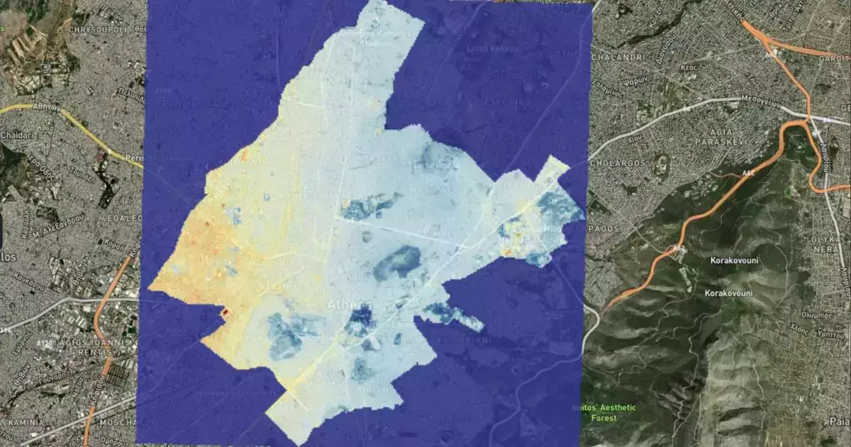
The platform’s strength lies in its ability to provide hyper-local insights at scalable costs. By leveraging high-resolution satellite imagery, EDI allows users to assess key environmental parameters with unprecedented detail. Core analytical layers include land surface temperature, urban heat island intensity, surface albedo, flood risk, tree cover density, carbon storage, and building or tree height classification. These datasets form the foundation for robust ESG reporting, enabling companies and public administrations to measure environmental performance objectively and consistently.
Beyond monitoring, EDI enables proactive planning, by integrating AI-powered simulation models. In this way, on just one platform, planners and decision makers will have a complete overview not only of the as-is situation, but of how different interventions will impact the current scenario.
Collaboration is another key pillar of the platform. Through map-based annotations and shared dashboards, EDI fosters a participatory governance model in which stakeholders can exchange feedback and co-design solutions. This approach resonates with the concept of Urban Living Labs, where knowledge sharing and stakeholder engagement accelerate the adoption of sustainable interventions. By embedding such mechanisms into its architecture, EDI transforms ESG policies into living processes shaped collectively by governments, businesses, and communities.
Future developments will further enhance the platform’s usability. Planned features include natural language interaction with data through AI-powered chatbots, enabling users to query complex datasets in plain language, and automated compliance reporting, which will allow the instant generation of sustainability reports aligned with the most relevant standards.
Latitudo40’s approach demonstrates how Geospatial Intelligence Platforms can become the backbone of modern sustainability governance. By merging earth observation data with simulation and collaboration tools, Earth Data Insight provides the clarity and foresight required to design impactful ESG policies. For municipalities, it means planning greener, more resilient cities; for real estate and insurance, it enables risk assessment and asset protection; for research institutions, it offers validated datasets to advance climate science.
Ultimately, EDI embodies the transition from fragmented, backward-looking ESG reporting to integrated, data-driven sustainability intelligence. It empowers organizations to move beyond compliance, fostering a strategic vision where environmental monitoring, predictive modeling, and stakeholder engagement converge to build a more resilient and sustainable future.
Conclusions: Geospatial Intelligence as a Driver for Climate Resilience and ESG Policies
The way organizations design and implement ESG strategies is rapidly changing. Traditional ESG reporting tools provide useful insights, but they often fail to capture the dynamic, real-world complexity of climate risks and sustainability challenges.
This is where geospatial intelligence platforms are redefining the game. By integrating earth observation data with advanced simulation models, they allow companies, cities, and investors to not only monitor their environmental footprint but also predict the impact of future interventions. The result is smarter, faster, and more effective ESG policies that deliver measurable improvements in climate resilience and sustainability performance.
With Earth Data Insights, Latitudo40 brings this vision to life. The platform transforms high-resolution satellite data into clear, actionable insights, accessible to everyone through a powerful and intuitive SaaS solution. From monitoring urban heat islands to estimating carbon storage or predicting flood risks, Earth Data Insights makes it possible to design sustainability strategies that are transparent, science-based, and impactful.
The future of ESG lies in the ability to combine monitoring with foresight, compliance with innovation. Organizations that adopt geospatial intelligence will not only meet regulatory requirements but also position themselves as leaders in sustainable transformation. With Earth Data Insights, we are sharing a more sustainable future. Together.

.webp)


.webp)


