
.svg)


.svg)
Topic
Text
Latitudo 40 applies earth observation and satellite data from Planet to advance disaster management solutions. In Cilento, the Tree Height Estimation Layer was used to identify trees at risk of falling onto railways, preventing derailments and improving safety. This scalable approach strengthens climate resilience while supporting the sustainable management of green infrastructure.
Article
Content
Understanding Disaster Management in the Age of Climate Change
Disaster management is a multidisciplinary field that focuses on reducing risks, preparing for crises, and ensuring effective response and recovery when disasters occur. Its scope ranges from prevention and early-warning systems to post-event recovery, integrating science, technology, and policy into a coordinated framework. The urgency of this discipline has grown significantly in recent decades as climate change intensifies the frequency and severity of extreme events such as floods, wildfires, and landslides. These phenomena not only disrupt communities and infrastructures but also create cascading risks across natural and built environments.
A modern approach to disaster management increasingly relies on data-driven strategies to anticipate threats before they materialize. Traditional ground-based assessments, while valuable, often lack the spatial and temporal resolution needed to monitor large and complex territories. This is where Earth Observation technologies and satellite data play a transformative role. By continuously monitoring environmental conditions at global scale, satellites deliver actionable insights that help decision-makers assess vulnerabilities, design preventive interventions, and optimize the allocation of resources.
In this context, climate resilience becomes the guiding principle: the capacity of societies and infrastructures to absorb shocks and adapt to changing conditions without compromising long-term sustainability. Building resilience requires not only engineering solutions but also the integration of green infrastructure strategies, such as maintaining healthy ecosystems that naturally mitigate hazards. The fusion of these approaches with satellite-enabled monitoring creates an effective ecosystem for disaster risk reduction.
As extreme climate events become systemic rather than exceptional, investing in advanced disaster management practices is no longer optional. It is a strategic necessity that safeguards lives, minimizes economic losses, and ensures the resilience of critical infrastructures worldwide.
Railway Derailment Risks and Vegetation Hazards
Railway infrastructures are particularly vulnerable to environmental factors, and vegetation management is one of the most critical yet underestimated challenges. In regions increasingly exposed to storms, floods, and landslides, tall or unstable trees represent a significant hazard: when falling onto railway tracks, they can cause service disruptions, costly damages, and, in the worst cases, derailments with severe human and economic consequences.
Traditional vegetation inspections along railways often rely on periodic field surveys. While effective on a local scale, these approaches struggle to provide continuous, large-area coverage and may leave risk zones undetected until problems arise. The growing complexity of climate dynamics demands more proactive and data-driven solutions.
This is where earth observation and satellite data become essential. By integrating remote sensing with predictive models, it is possible to identify vegetation patterns that threaten railway safety before incidents occur. This method not only enhances disaster management but also supports climate resilience strategies, ensuring that critical transport infrastructures remain functional under increasing environmental stress.
At Latitudo 40, this challenge is at the center of our research. By focusing on vegetation-related derailment risks, we aim to demonstrate how innovative monitoring systems can transform rail safety, reduce maintenance costs, and build sustainable, resilient green infrastructure.
Leveraging Planet Satellite Data for Disaster Management
Effective disaster management requires timely, accurate, and scalable information. Planet, one of the world’s leading providers of satellite data, offers unique capabilities that are crucial for risk prevention and infrastructure monitoring. With a constellation of high-resolution satellites capturing imagery at near-daily frequency, Planet delivers unprecedented visibility over dynamic environments, enabling stakeholders to track changes with both spatial detail and temporal continuity.
For earth observation applications, this means the ability to monitor vast railway networks or remote landscapes with the same level of precision as localized surveys, but at a fraction of the cost and time. Planet’s imagery provides hyperlocal insights into vegetation cover, terrain variations, and other environmental conditions that can pose risks to critical infrastructure.
Through our partnership with Planet, Latitudo 40 integrates these datasets into a broader disaster management framework. By combining satellite imagery with advanced AI models, we transform raw data into actionable intelligence that informs maintenance strategies, optimizes resource allocation, and enhances climate resilience planning. This approach not only reduces the likelihood of accidents but also strengthens the long-term sustainability of green infrastructure, ensuring safer and more efficient transport systems.
Tree Height Estimation Layer: A Key Tool for Risk Prevention
Among the most innovative applications of satellite data for disaster management is the estimation of vegetation height. The Tree Height Estimation Layer provides high-resolution information on canopy structure, allowing organizations to identify and quantify potential hazards linked to tall or unstable trees near critical infrastructures such as railways, roads, or power lines.
This dataset is generated by combining earth observation imagery with advanced AI and machine learning models capable of estimating tree height with remarkable precision. The layer is updated regularly and can cover large geographic areas, providing a scalable solution that complements or replaces costly ground surveys. By visualizing the distribution of tree heights, decision-makers can prioritize zones at higher risk, plan selective interventions, and avoid unnecessary maintenance in areas where vegetation poses no real threat.
For railway safety, the Tree Height Estimation Layer is particularly valuable. Falling trees are among the most common causes of service disruptions and derailments. By integrating this layer into monitoring workflows, operators can proactively mitigate risks, reducing both economic losses and human safety concerns.
Beyond transport, the layer also supports broader climate resilience strategies and the sustainable management of green infrastructure. Healthy vegetation plays a crucial role in mitigating climate impacts, but it must be managed responsibly. The Tree Height Estimation Layer helps balance conservation goals with risk prevention, offering actionable intelligence that bridges environmental stewardship and infrastructure protection.
This integration of cutting-edge geospatial analytics into operational planning demonstrates how earth observation technologies can reshape the way societies address climate-related challenges, turning satellite insights into tangible solutions for disaster risk reduction.
Case Study: Railway Monitoring with Satellite Imagery
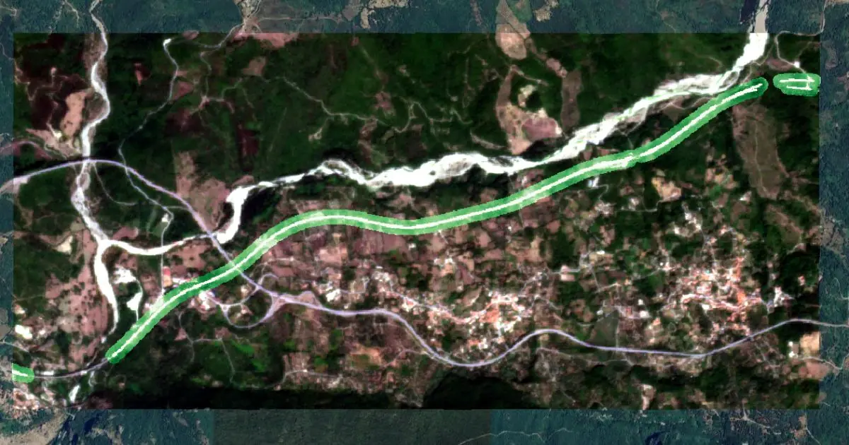
The Cilento region in Southern Italy presents a challenging context for railway safety. Its mountainous terrain, dense vegetation, and exposure to extreme weather events amplify the likelihood of natural hazards. In particular, falling trees along railway lines represent a critical risk factor for derailments. Latitudo 40, in collaboration with Planet, applied advanced earth observation techniques to assess and mitigate these vulnerabilities through a pilot study focused on a railway corridor in this area.
Using Planet’s high-resolution satellite data, we were able to obtain near-daily imagery of the railway network and surrounding vegetation. The integration of this data with the Tree Height Estimation Layer allowed us to map canopy heights along the corridor with high spatial precision. By overlaying tree height information on the railway trajectory, analysts could identify “critical zones” where vegetation exceeded safe thresholds or was more likely to fall due to slope instability and storm exposure.
This methodology provided several operational advantages. First, it enabled a proactive approach to disaster management, where risks are predicted and addressed before incidents occur. Rather than deploying costly and time-consuming ground surveys across the entire network, railway operators can now focus resources on targeted areas highlighted by satellite-driven analytics. This shift not only reduces maintenance costs but also increases the accuracy of interventions, minimizing unnecessary vegetation removal and supporting the sustainable management of green infrastructure.
Moreover, the Cilento case demonstrates how satellite data enhances both spatial and temporal monitoring. Periodic field inspections capture conditions at a single moment, but vegetation dynamics are continuous and influenced by seasonal growth and climate variability. By leveraging Planet’s frequent image refresh, Latitudo 40 ensured that changes in canopy height and distribution were tracked over time, improving situational awareness and resilience planning.
The study also underscored the scalability of this approach. The combination of Tree Height Estimation Layer with Planet imagery is not limited to the Cilento railway; it can be replicated across global transport networks, power lines, and other critical infrastructures. This adaptability makes the methodology a powerful tool in building climate resilience for regions increasingly exposed to storms, floods, and landslides.
In practice, the Cilento pilot demonstrated how advanced earth observation can transform railway safety from reactive maintenance to predictive management. By turning satellite imagery into actionable intelligence, Latitudo 40 provided a framework that safeguards transport infrastructure, reduces risks of derailments, and aligns with broader climate adaptation strategies. The result is a more efficient, data-driven, and environmentally conscious approach to disaster prevention—one that can serve as a model for infrastructure operators worldwide.
Scaling Climate Resilience with Global Earth Observation Solutions
The Cilento case study illustrates how targeted interventions supported by earth observation technologies can significantly reduce risks to critical infrastructure. However, the true value of this approach lies in its scalability. The combination of high-frequency satellite data, AI-driven analytics, and thematic layers such as tree height estimation can be applied to multiple geographies and sectors, creating a universal framework for disaster management.
From railways to power grids, pipelines, and road networks, infrastructure systems worldwide face growing exposure to climate-related hazards. Storms, floods, and wildfires no longer represent isolated events but recurring phenomena with increasing intensity. In this context, the ability to continuously monitor environmental conditions and anticipate vulnerabilities is not only a technical advantage but also a strategic necessity for governments, infrastructure operators, and urban planners.
By adopting satellite-enabled disaster management, organizations can shift from reactive to predictive strategies. Instead of responding after a disruption, they can leverage near-real-time monitoring to identify risks in advance and deploy resources with greater efficiency. This reduces operational costs, minimizes downtime, and most importantly, protects human lives. At the same time, selective interventions informed by geospatial insights support the preservation of green infrastructure, ensuring that natural ecosystems continue to provide their protective and regenerative functions.
At Latitudo 40, our mission is to transform raw data into actionable intelligence that bridges science, technology, and environmental stewardship.
By scaling the use of earth observation tools, we aim to empower organizations worldwide to prevent disasters before they occur, protect vital infrastructures, and create a safer, more resilient future.

.webp)


.webp)


