
.svg)


.svg)
Topic
Text
Agritech is transforming farming with the integration of satellite Earth Observation and robotics. Latitudo 40’s rover LAURA, tested in the SALUS project, validates satellite data through LiDAR-based field measurements, supporting precise crop management and soil management. This synergy enables green agriculture, reducing resource waste and increasing resilience against climate change.
Article
Content
Agritech challenges in the era of climate change
Agriculture today faces unprecedented challenges driven by climate change, resource scarcity, and the pressure to produce more with less. Rising global temperatures, irregular rainfall, and the increased frequency of extreme weather events directly affect soil quality, crop yields, and water availability. Farmers must balance productivity with resilience, while also complying with stricter environmental regulations and consumer demand for sustainable practices.
In this complex scenario, agritech—the application of advanced technologies to agriculture—emerges as a strategic response. By integrating digital tools, robotics, and remote sensing systems, agritech supports green agriculture practices that optimize resource use while reducing environmental impact. Unlike traditional approaches, which often relied on uniform treatments across entire fields, modern agritech enables precision interventions at the scale of individual plots or plants. This paradigm shift enhances both soil management and crop management, ensuring healthier soils, higher yields, and reduced chemical inputs.
Key principles of agritech include data-driven decision-making, real-time monitoring, and automation. For instance, soil parameters can be continuously assessed to guide irrigation or fertilization schedules, while crop growth stages can be tracked to anticipate risks from pests or diseases. These tools provide a level of situational awareness that was previously unattainable, enabling farmers to adapt quickly to changing conditions.
The transition to agritech, however, is not without barriers. High implementation costs, lack of technical expertise, and fragmented data ecosystems still slow adoption, particularly among small and medium-sized farms. Yet, as climate pressures intensify, the need for integrated solutions that combine satellite Earth Observation, ground-based robotics, and AI-driven analytics becomes increasingly urgent.
Ultimately, agritech represents more than just technological innovation: it is a framework for building resilient, sustainable agricultural systems capable of thriving in the face of environmental uncertainty.
The role of satellite data in green agriculture
Satellite Earth Observation (EO) has become a cornerstone of agritech, providing large-scale insights that are crucial for advancing green agriculture. Unlike traditional monitoring methods, satellite data offers continuous, objective, and repeatable observations over vast areas, making it possible to track crop performance, soil conditions, and environmental risks with unmatched spatial and temporal coverage.
One of the main advantages of EO lies in its ability to capture spectral information beyond what the human eye can perceive. By analyzing vegetation indices such as Normalized Difference Vegetation Index (NDVI) or Leaf Area Index (LAI), farmers and agronomists can assess plant health, detect early stress, and predict yield potential. These tools are essential for effective crop management, as they allow for targeted interventions—such as adjusting irrigation or optimizing fertilizer application—before problems escalate.
In parallel, satellites support advanced soil management strategies. Multi-spectral and radar sensors can monitor soil moisture dynamics, enabling precision irrigation that reduces water waste. Over time, this contributes to healthier soils and minimizes degradation, directly aligning with sustainability goals. Furthermore, long-term EO datasets provide valuable information for monitoring land use changes, biodiversity impacts, and compliance with environmental standards, reinforcing the transition to more resilient agricultural systems.
The scalability of satellite technology also addresses one of the sector’s major challenges: heterogeneity across agricultural landscapes. By integrating EO data with local weather forecasts and historical trends, agritech platforms can generate predictive models that guide farmers’ decisions at both field and regional levels. This combination of macro-scale monitoring and field-level insights improves operational efficiency while reducing reliance on chemical inputs, thereby supporting the broader objectives of sustainable agriculture.
While satellite data is a powerful enabler, its full potential is realized only when validated against ground truth measurements. Integrating EO with robotics and IoT systems ensures higher accuracy and reliability, bridging the gap between large-scale imagery and the specific conditions of individual fields. This synergy defines the future of smart agriculture, where space-based technologies serve as the foundation for data-driven and climate-resilient farming practices.
Robotics and LiDAR technology for advanced crop management
While satellite imagery provides a broad perspective, achieving reliable agricultural insights requires precise ground validation. This is where robotics plays a decisive role in modern agritech. Ground-based autonomous systems complement Earth Observation by capturing high-resolution measurements at plant level, ensuring that large-scale models are consistent with field reality.
In particular, rovers equipped with LiDAR (Light Detection and Ranging) technology have become crucial for advanced crop management. LiDAR generates three-dimensional “point clouds” that represent the exact geometry of plants, capturing details such as canopy height, density, and spatial distribution. These datasets allow for accurate estimations of biomass and growth patterns, which are essential for predicting yield and detecting anomalies early. Unlike traditional manual sampling, robotic surveys provide continuous, repeatable, and objective measurements, dramatically reducing uncertainty in decision-making.
The integration of robotics also enhances soil management practices. By navigating directly within fields, rovers can combine LiDAR scans with other sensors—such as multispectral cameras, thermal imaging, or soil probes—to assess soil compaction, moisture distribution, and nutrient levels. This level of granularity supports precision interventions, enabling farmers to optimize irrigation schemes or tailor fertilization to specific zones within a plot. The result is reduced input waste, improved soil health, and alignment with the principles of green agriculture.
Beyond monitoring, robotics opens the path to actuation. Some autonomous platforms are being designed not only to collect data but also to perform targeted operations, such as precision spraying. This dual capacity transforms them into integral components of sustainable farm management, bridging analytics and action in a single workflow.
Ultimately, robotic systems equipped with LiDAR act as a vital link between satellite-derived analytics and practical agricultural applications. By validating remote sensing data with precise field measurements, they ensure that digital agriculture solutions are not only innovative but also scientifically robust and operationally reliable.
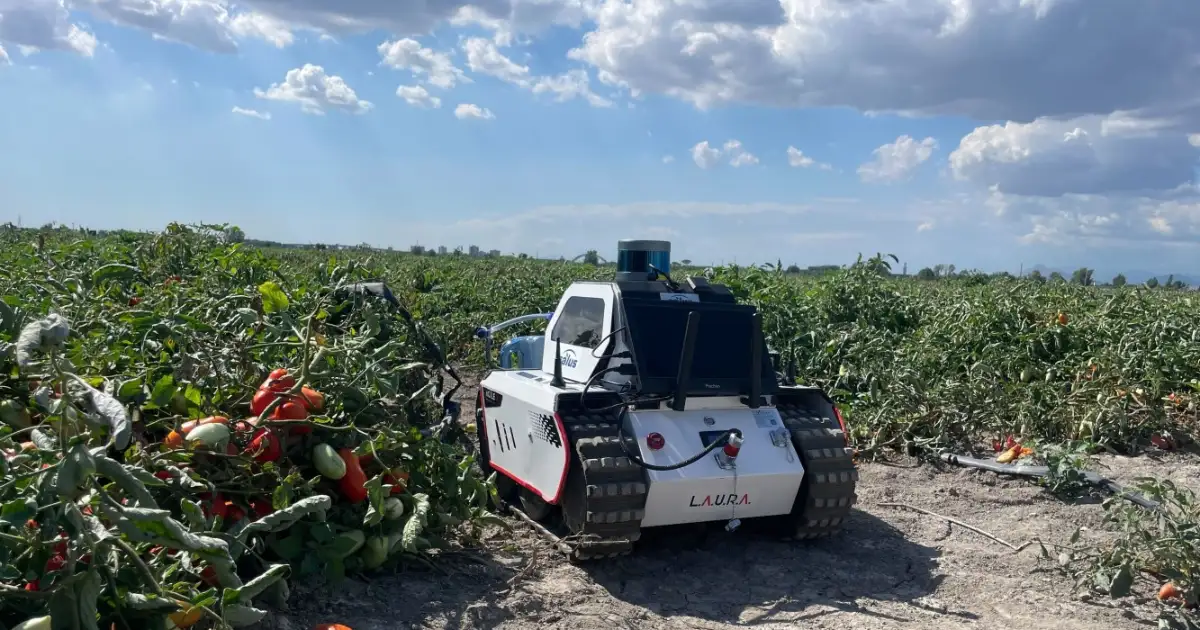
LAURA: Latitudo 40’s ground rover for soil and crop monitoring
At the intersection of robotics and satellite analytics, Latitudo 40 has developed LAURA, a ground rover specifically designed to support sustainable farming. Built to operate in real-world agricultural environments, LAURA provides a reliable bridge between large-scale satellite observations and detailed field-level measurements, enhancing both soil management and crop management strategies.
The rover is equipped with advanced LiDAR sensors, capable of generating precise three-dimensional models of crop structures. By mapping plant height, canopy density, and biomass distribution, LAURA creates a “digital twin” of the field, which can be used to validate and refine satellite-derived insights. This high-resolution dataset is essential for reducing uncertainty in yield estimations and for identifying localized anomalies that satellites may overlook.
What sets LAURA apart is its modularity and adaptability. The platform is designed not only for data acquisition but also for integration with additional sensing technologies, such as multispectral imaging or soil probes. This flexibility allows farmers and researchers to tailor the rover to specific agronomic needs, whether monitoring water stress, evaluating nutrient deficiencies, or tracking the development of particular crops.
Beyond monitoring, LAURA has been conceived with an eye toward actuation. The system can be enhanced with tools for precision spraying, enabling targeted application of inputs directly where needed. This approach minimizes chemical use, lowers costs, and supports the goals of green agriculture by reducing environmental impact.
In practice, LAURA represents a new standard for robotic support in agritech. By combining robust field autonomy with advanced sensing capabilities, it empowers decision-makers with validated, actionable data. For farmers, this means improved resource efficiency and resilience; for researchers, it offers a reliable platform to test and validate innovative agronomic models. Ultimately, LAURA exemplifies how robotics can elevate data-driven agriculture from theoretical potential to practical implementation.
Case study: LAURA in the SALUS project for sustainable agriculture
S.A.L.U.S. is a technological initiative aimed at developing an advanced geospatial platform to support agricultural businesses in crop management, with a particular focus on combating plant diseases and promoting sustainable use of agricultural resources. The system integrates satellite data, IoT sensors, drones, and advanced robotics to monitor environmental and biophysical crop conditions, predict pathogen development, and optimize agricultural management strategies. Within this framework, LAURA played a central role, validating satellite data through precise ground-based measurements and translating complex analytics into actionable insights for crop management and soil management.
A key field campaign took place in Marigliano, Italy, focusing on tomato cultivation—a crop highly sensitive to climate variability and water stress. The main objective was to estimate biomass with greater accuracy, a critical variable for predicting yields and optimizing resource allocation. Using its LiDAR system, LAURA generated detailed 3D point clouds of the plants, capturing structural characteristics at millimetric precision. This dataset enabled the creation of a digital twin of the field, an advanced model that goes beyond satellite imagery by reflecting the true physical state of the crop.
To ensure the robustness of the measurements, the raw LiDAR data underwent sophisticated processing. Clustering algorithms were applied to identify individual plants and calculate canopy height. This methodological rigor provided an accurate ground truth, which was subsequently integrated with satellite observations to enhance model calibration.
The outcomes of SALUS highlight the added value of coupling robotics with EO in agritech. By validating satellite-derived indices with precise field measurements, the project reduced uncertainty in biomass estimation and created a more reliable foundation for decision-making. This approach supports farmers in adopting green agriculture practices, from reducing unnecessary chemical inputs to better managing water and soil resources.
Moreover, SALUS showcased LAURA’s potential beyond monitoring, laying the groundwork for future applications in targeted interventions such as precision spraying. The project demonstrated not only the technical feasibility of integrating robotics and satellite data but also its strategic importance in building sustainable and climate-resilient agricultural systems.
Conclusions: the future of agritech between space and robotics
The convergence of space-based technologies and ground robotics marks a decisive turning point for the future of agritech. As climate pressures continue to intensify, farmers require tools that not only provide large-scale insights but also deliver validated, actionable information at the level of individual fields. The integration of satellite Earth Observation with autonomous rovers such as LAURA creates a multi-layered monitoring ecosystem that strengthens both crop management and soil management strategies.
Looking ahead, the evolution of green agriculture will depend on the ability to transform data into precise actions. Satellites offer unmatched coverage and historical continuity, while robotics ensures accuracy, adaptability, and direct interaction with crops and soils. Together, these systems reduce uncertainty, enhance resource efficiency, and allow interventions that minimize environmental impact. This dual perspective—from space and from the ground—provides a holistic view of agricultural systems that is essential for building resilience against unpredictable climate events.
The next frontier lies in operational scalability. By combining AI-driven analytics with continuous satellite monitoring and robotic validation, farmers can access real-time decision-support systems that guide irrigation, fertilization, and pest management with unprecedented precision. Moreover, as robotic platforms expand their capabilities from observation to actuation, they will become integral to the transition from conventional farming to fully digital, sustainable operations.
For stakeholders across the agricultural value chain, this technological convergence is more than an efficiency driver: it is a strategic enabler of sustainability. It supports compliance with environmental regulations, reduces dependency on chemical inputs, and fosters long-term soil health. In this sense, agritech is not only about boosting yields but about redefining agriculture as a resilient, adaptive system capable of thriving under global change.
The experience of the SALUS project demonstrates the feasibility and value of this approach. As innovation continues, the integration of satellites and robotics will no longer be a research experiment but a standard practice in the toolkit of modern agriculture, ensuring that future farming systems are productive, sustainable, and climate-ready.

.webp)


.webp)


